Maps for Direct Marketing
to Start Using MapBusinessOnline for Direct Marketing – Take a FREE Trial
Web maps can add tremendous value to direct marketing processes by providing fast geographic customer visualizations, territory management options, and route-planning. Web mapping software is a widely available and affordable cloud services solution that can improve marketing response rates and helps drive results.
Direct marketing is so intimately connected with addresses, streets, zip codes, and jurisdictions; it seems unbelievable that web map services are not used more by marketing professionals. If you don’t add web mapping software to your array of marketing tools then your business may be missing a competitive edge.
Common applications of web maps for direct marketing include the creation of marketing and sales territories, tracking deliveries by zip code, and the visualization of measured results by zip code or county. But there are many advanced direct marketing strategies that web mapping makes possible.
Targeting by Region
Testing your marketing approach is a proven strategy that improves overall direct marketing results. Web mapping software can add geographic categories to your campaign testing, helping to speed up the process and fine tune response rates. A good start is simply importing your complete prospect and/or customer lists and observing where the greatest densities of clients or potential clients are located. Visualization of target customer/prospect locations can quickly help determine an area of market focus. Perhaps testing in one or more rural and urban areas at the same time will reveal interesting response trends? Perhaps testing counties vs. zip codes is more effective?
Not all geographic test results will be so directly related to mapping, but testing your product or service based on geographic categories will often reveal surprising outcomes, or perhaps confirm suspected ones.
Segment Your Lists
Web maps can be an effective way to target your direct marketing activity to a specific segment of your audience. A full prospect list, imported and displayed on a web map, is a pool of potential recipients for your messages and calls to action. By segmenting a prospect list geographically you can fine tune your message to appeal to a regional audience – to regions as small as zip codes. Regional segmentation can be very effective for products with variations that may sell better in specific areas. For instance, certain flavors of chewing gum may sell better in Louisiana while others sell better in New England. A variable message matched to regional tastes may drive more effective response rates. Additionally, price discounting can be applied by region to encourage the sale of products outside of the areas where they traditionally dominate.
An example regional marketing need might be: which metropolitan areas outside of New England are more likely to purchase Boston Red Sox merchandise?
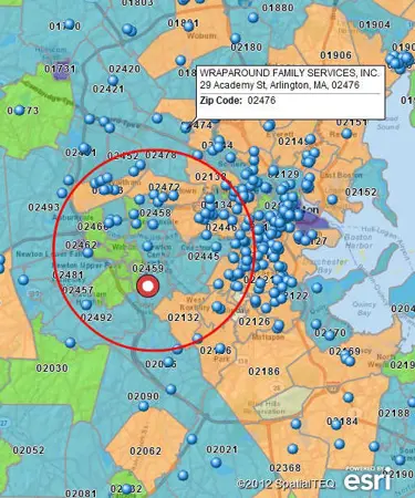
Web mapping software offers a variety of ways to segment purchased prospect lists or in house customer lists. Radius maps or radius searches are a basic tool offered by the best web mapping software solutions. A radius search is when you draw a circle, at varying radii, around a section of your imported data. The search results can be exported to third party applications.
Thinking baseball again use your business mapping application’s radius search tool or radius map to create zip code areas within fifty miles of six large baseball cities. Any prospect accounts that fall within these zip codes are targets for direct marketing test campaigns.
Map Filter Your Data
Another approach to list segmentation is to filter your prospect data by county, zip code, or state regions. Some web map applications will allow a filtered search of your total prospecting database. Returning to our Red Sox example again, in your map application select your prospecting database and filter the data by those target zip code areas around metropolitan centers. Now your test data will reflect only the zip codes you chose to review. Filtering your data by zip code, or county, can expose areas where response rates are particularly low, perhaps skewing results of the whole test.
Census Data
Analysis of your direct marketing test areas can be expanded by adding Census data to your selected target areas. Census demographic data is specifically organized by zip code, county and state, making it extremely user friendly for web mapping users. A few clicks within your mapping application will reveal population densities and average house hold incomes for your most critical prospecting zip codes. Perhaps there are densely populated zip codes with higher average household incomes you haven’t tested yet?
Many mapping applications will analyze zip code and county demographic breakdowns. This provides a quick way to show the zip codes with the highest amount of expendable income – ripe for Red Sox paraphernalia. A quick query by county regarding the population density at a specific age bracket can provide an array of target markets for a new product. Will Blue Red Sox hats sell better in Maine or Florida? And will they do better with teens or octogenarians? A good web mapping application can help visualize the market targets and the results. You can save your marketing results as web maps for quick visual references. Name the file, “Red Sox Nation – True of False?”
Direct Marketing Gold
Web mapping cloud services are common today. The term “Cloud Services” implies the application is easy-to-use, required IT support is minimal, and overall application costs are low. With a little shopping you can find all the functionality we’ve talked about in this white paper plus the security you require to protect your data.
So whether you’re a small, in-house direct marketing organization or a large consulting firm supporting many clients, there are web maps available to support your work flows and to help measure and improve your direct marketing results.
Affordable business intelligence maps to inform your business, right now.
Learn How Our Customers are Succeeding with MapBusinessOnline

"In a large company, with many layers of sales teams, sales management, territories, operations teams and distribution, it is vital to have a solution to quickly and easily display country and regional maps. I have tried multiple other mapping solutions in the past only to be frustrated by their limitations or by their complexity. MapBusinessOnline perfectly fits my need. MBO has the versatility to allow me to build somewhat complicated maps but also allows me to knock out the quick, one-off request. MBO continues to add features and I am excited to see what new features come out next."
Dave Perek
Sr Business Analyst
Schneider Electric


"MapBusinessOnline is an amazing tool that I use every week. When you are creating zip code footprints and trying to determine what zip codes fall within a range of a business, this tool couldn't be any easier to use. There's actually so many functions that are great but specifically I use MapBusinessOnline to create either a mile radius or a drive time radius from a business location. I then use that radius to determine which zip codes fall within the radius. Why is this important? Because I then export the zip codes and use another software that gets me exact counts of how many people fall within that radius in those zip codes. It's Amazing!
I highly recommend this software!"
Chris Farcher
Account Manager
The Mailworks

"We use MapBusinessOnline to prepare for sales meetings. The program’s territory mapping enables color-coded sales territories by zip-code helping to define sales responsibilities and keeping our focus on selling."
Christie Shedd
Operations Manager
AFTCO Bluewater
Popular MapBusinessOnline features
Use maps to create marketing campaigns

Search potential customers spatially and by demographics. Organize search results into marketing lists. Export marketing lists in Microsoft® Excel spreadsheets.
Build fast map visualizations of your business data

Map business data from various sources by street address, city name, ZIP code, or latitude and longitude. Plot 250,000 or more locations on a map at once. All you need to start is a spreadsheet with business data.
Design and visualize sales territories

Use our sales territory mapping software to create sales territories by ZIP code, county, or state. Aggregate demographics and sales data by territory. Search business data inside sales territories. Highlight territory overlap.
Search data spatially with radius maps

Explore your data within circle or polygon areas. Organize search results into marketing lists or market areas. Export ZIP code demographics, territories, or marketing lists in Microsoft® Excel spreadsheets.
Add drive time polygons to your market analysis tools

Create drive time polygons to identify actual market areas by hour of day and day of week. Explore your data within drive time areas. Improve direct mail campaigns.
Perform market analysis for multiple sites

Search & segment data from multiple centers. Generate market area profiles. Find nearest store or pick up locations. Batch calculate distances, as well as driving times to multiple locations. Aggregate demographic data. Enrich a dataset with demographic or geographic variables.
Visualize business data on map with various symbols

Assign specific symbols, colors, and sizes to your data points on map. Choose from a wide variety of symbols or create your own. Visually define customers and prospects across multiple locations using symbols color coding.
Color code maps by ZIP code, county, or state

Import business data by ZIP code to show it geographically. Create colorful maps for business analysis that connect real Census data to locations on the ground.
Search business data in full-featured tabular view

Search your data records by business name. Sort data view by any variable. Filter data by custom criteria. View search results on map.
Share business maps

Create interactive maps and share with friends, colleagues, dealers, customers, prospects or vendors. Share territory maps. Email saved JPEG and PNG files or embed map files in PowerPoint presentations. Includes PDF export for larger print formats.


