Radius Maps

What Can You Do with Radius Maps?
- Convert a radius map into a sales, service, or franchise territory.
- Search and segment your imported business data using radius maps: import customer lists, display customer locations, and batch calculate their proximity to your offices or sales rep homes.
- Look up ZIP codes or counties by map radius and export the selection for use in 3rd party apps.
- Query demographic data by radius - collect and export population, income, and household info for a given circle.
- Search business listings by radius and populate prospect lists.
- Plan marketing campaigns using customer and prospect lists.
- Plan sales trips by creating efficient multi-stop vehicle routes with turn-by-turn directions.
- Share radius maps as image files, interactive maps, or large-format printouts.
- Add circles of varied radius around multiple centers to a map.
- …and more.
All the options are also available for drive time or distance radius maps.
Benefits of Radius Mapping
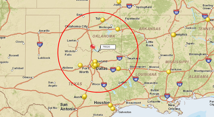
Here’s a simple example of how radius mapping can be applied to a sales situation. Suppose you’re opening a new sales office in a specific geographic region, and you want to target your sales efforts within the 50-mile radius of your new headquarters. You can use radius mapping to draw a circle that extends 50 miles in every direction from your office. You’ll then be able to easily determine what data points (customers, stores, competitors, ZIP codes, counties, cities, etc.) exist within that circle. Moreover, you’ll get the demographic characteristics of the area within it. Consequently, mapping a radius helps you quickly visualize your sales opportunities, and more effectively deploy your sales staff and marketing resources.
But there’s much more: radius maps are powerful tools for business development and strategic planning. When they are used together with accurate map layers and current demographic data, they offer several benefits to organizations of any size. These include:
Simplifying the design of sales, service, delivery, or franchise territories. Radius search helps you quickly select all the ZIP codes or counties in the area, assess its population and income, and define it as a sales territory of target size.
Highlighting the location-specific data relevant to your business. When you create a radius map with MapBusinessOnline, you can populate it with the geographic, demographic, firmographic, or imported data you choose.
Visualizing your customers, prospects, and competition in an area. Radius mapping software lets you focus on specific areas to determine whether they're adequately served by either your organization or your competition. This, in turn, helps you identify areas ripe for expansion and ensures your resources are directed where they will be most effective.
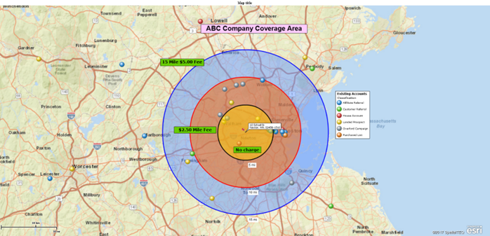
Improving staff assignments and route planning. From helping your sales team reduce travel times to having technicians available to respond to incidents faster, a radius map can benefit businesses dealing with logistic challenges in a wide range of industries. You can create multiple concentric circles for modeling delivery or service zones around one central location.
Radius mapping software is helpful for retail operations, franchise businesses, service and maintenance providers, insurance companies, real estate agencies, and more.
How to Create a Radius Map
Easily create radius maps using MapBusinessOnline business mapping software. Select a center point and create a circle or radius map of your target area by dragging your cursor until the drawn circle is of the desired radius. Or drop a new point on the map and enter your radius in miles. The circle lets you query geographic, demographic, and imported customer data. Save the data within the circle as a marketing list, market area, or territory, or simply export it to Excel. You can export Census demographics for the circle, too. To share your radius map, save it to a PDF file, or embed it in a PowerPoint presentation, or create a shared interactive map that others can open in our free viewer app.
Additionally, MapBusinessOnline supports creating multiple circles around distinct centers and creating concentric circles to form a ring:
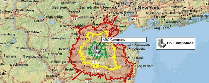
Creating drive time or drive distance polygons is equally easy with MapBusinessOnline:
See MapBusinessOnline in Action
Request a demo
Learn How Our Customers are Succeeding with MapBusinessOnline

"You guys are awesome! I used the MapBusinessOnline trial to get promoted to a sales position within my company. I showed them how I would work my territory with great MBO printed maps that showed projected sales dollars by account locations. I got the Job!"
Jeff Krieger
Territory Manager
Mizuno USA
"Truly the easiest business mapping application I have ever used."
Chad Seaverns
National Sales Manager
www.nfdnetwork.com
"We used MapPoint for years and desperately needed a replacement solution. This one fits the bill and is actually much better in many ways. Especially in a team environment. We do logistics with routing technicians to jobs for roll outs. This helps our team working thousands of sites over multi month projects. Also, easy to manage licenses for users.
Example business case would be taking 3000 locations, and planning how you will have multiple different technicians visit an area or region of these locations over 3 months. Each visit will take x amount of time. They only work certain hours of the day, and you have to plan in drive time, so the day actually makes sense and the route is efficient."
Jay Walker
IT Director
jay.walker@nettechnology.com
Network Engineering Technologies


