Batch Analysis Tools
Analyze Location Data at Scale
MapBusinessOnline Batch Analysis Tools let sales, marketing, and operations teams perform geospatial analysis across thousands of records in minutes. Quickly segment customers, calculate distances, and enrich business data with demographics and map layers — all in one efficient workflow. These tools help organizations:
- Segment customers into targeted lists and export results for reporting.
- Allocate customers to the nearest store or service center.
- Run bulk distance and drive-time calculations.
- Summarize demographics across trade areas for site planning, performance evaluation, and void analysis.
- Enrich customer or prospect data with demographics and geographic areas such as ZIP Codes or counties.
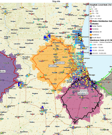
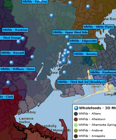
Segment and Search Data from Multiple Centers
Search data around multiple locations within imported datasets. For example, find all customers within a distance of multiple stores. Add results as marketing lists or generate territories. Create hundreds of drive-time polygons or circles around designated “Store” location points. Search all store points for surrounding customer data within a specified radius and export the results to a CSV file. Match patients to medical centers, prospects to planned events, or product owners to repair locations.
Addresses typical questions:
-
Which customers are within 10 miles of all my store locations?
-
Which patients fall inside a 15-minute drive of multiple medical centers?
-
Can I export customer lists segmented by several service hubs at once?
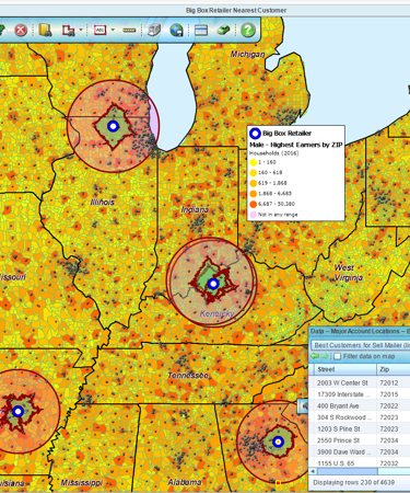
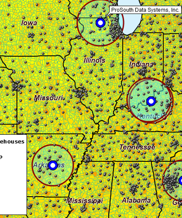
Find the Nearest Stores or Pickup Locations
Find multiple nearest locations, from one dataset to each location in a second dataset. Determine nearest locations based on driving distance, time, or straight-line calculations. For example, allocate each customer to the nearest store, service center, or warehouse to streamline operations and improve customer coverage.
Addresses typical questions:
-
What is the closest store to each of my customers?
-
How do I assign every customer to the nearest service or sales location?
-
Which warehouse is nearest to each delivery point based on drive-time?
Aggregate Customer Data
Aggregate customer data and related sales activities within a specified radius of each store location. Measure how many customers and how much sales fall within each store’s trade area. Compare branch performance by geography to identify high- and low-performing locations.
Addresses typical questions:
-
How many customers live within a 20-minute drive of each store?
-
What is the total sales volume inside each store’s 25-mile trade area?
-
Can I compare customer counts across multiple branches?
Batch Calculate Distances and Drive Times
Use MapBusinessOnline to analyze the driving distances and times between all points in one or two datasets.
Addresses typical questions:
-
What are the drive times between all warehouse and customer pairs?
-
How far do sales reps travel on average to visit assigned clients?
-
What are the total driving distances my team covers across all customer visits?
Summarize Demographic Data
Summarize demographic data within a specified radius. Easily append business data with multiple demographic categories based on search results from multiple locations. Access comprehensive library of demographic data.
Addresses typical questions:
-
How many households are within a 10-mile radius of each proposed store site?
-
How does median income vary within a 15-minute drive of my store locations?
-
Which trade areas have the strongest match to my target age profile?
Enrich a Dataset with Demographic or Geographic Variables
Add MapBusinessOnline map layer information to imported data. Append ZIP Code, City Limits, County, State, MSA, or Census tract data to target datasets. Add multiple map layers and demographic categories to your analysis.
Addresses typical questions:
-
Can I add ZIP Code or county information to my customer list?
-
How do I append population and income data from the ZIP Code or county where each prospect is located?
-
What metropolitan areas do my accounts fall into?
Ready to Run Batch Analysis?
Process thousands of customers, facilities, and trade areas in minutes — get started today.
See MapBusinessOnline in Action
Request a demo
Learn How Our Customers are Succeeding with MapBusinessOnline

"I have had the pleasure of using MapBusinessOnline for the past 5 years and it is an excellent and affordable tool for my clients. I am a franchise consultant, and many of my clients are just starting to get into franchising. The first main question many of them have is they don’t know the demographics around their current location, so they don’t know how to create territories for their franchisees. I am able to easily utilize MapBusinessOnline to draw a prototype territory around their existing location, do a deep dive into the many different demographics that MapBusinessOnline offers, and help the client determine the basics of their new territories, including mileage, population, household count, purchasing habits and age distributions. This tool has been so helpful that many of our clients obtain their own accounts as they begin to sell franchises and grow their business. Thank you, MapBusinessOnline, for providing such a helpful tool that is affordable and easy to use!"
Colette Bell
Director of Business Development
SMB Franchise Advisors

"We used MapPoint for years and desperately needed a replacement solution. This one fits the bill and is actually much better in many ways. Especially in a team environment. We do logistics with routing technicians to jobs for roll outs. This helps our team working thousands of sites over multi month projects. Also, easy to manage licenses for users.
Example business case would be taking 3000 locations, and planning how you will have multiple different technicians visit an area or region of these locations over 3 months. Each visit will take x amount of time. They only work certain hours of the day, and you have to plan in drive time, so the day actually makes sense and the route is efficient."
Jay Walker
IT Director
Network Engineering Technologies

"We quickly grew from a one location small-business to a franchised business with 8 locations across the country. After selling our first few franchises, I realized I needed a way to map out a potential franchisee's territory. Initially I just wanted to be able to create territories based on drive time from an address, which is easy to do with MapBusinessOnline. What I didn't know I needed was the ability to export census data, including information on other dog related business, which is very helpful!"
Steve Sentner
Co-Owner
Paw & Order Dog Training


