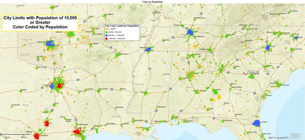
This week a customer wrote in and asked, “How do I view only the cities with a population of 10,000 people or greater, using Map Business Online?”
That’s a great question that Map Business Online can assist with. A good business mapping software will provide a demographic data filtering tool. Demographic analysis adds a completely new dimension to zip code mapping, market analysis, and customer visualizations. That’s why the founding fathers invented the US Census requirement in the Constitution – they were all about business mapping.
Remember, George Washington was a map surveyor. Oh. Snap.
We have several ways to approach the city by population challenge. The first approach involves importing a list of City Points from Map Business Online’s included Public Data library. The second approach uses our City Limits layer available to all full-year subscribers of Map Business Online.
Public Data, City Points
For general Map Business Online subscribers, you can click the Plot Data Button and choose the lower option to Select Data Already Uploaded, in the drop-down choose Public Data. Then select the Cites and Towns option and import that data which will place 6,715 cities on the map as points.
The Data Window automatically opens and shows you the Cities dataset in a tabular data view. Notice the Population column included in the data. We’re going to filter the City layer based on the Population column.
- Click the Filter Button on the Data Window Toolbar.
- In the data selector, where it says Capital, drop down to select Population
- In the top Modifier drop down select (>) to indicate “Greater Than”
- In the far-right box type in 10,000 for your population guide
- Click the Filter button in the lower right
Your Data Window view now shows only 2,903 city records of the total 6,715 cities. You’ll find that noted in the lower left. You can export that list by creating a Marketing List (Colored Arrows button on the Data Window toolbar) to save by name. Then use the Export button to the far right of the Data Window toolbar.
To view only those records on the map, Check the Filter Data on the Map button on the upper left-hand corner of the Data Window. Feel free to adjust symbol colors, size or even color code those records by population using the Three Colored Cannon Ball icon on the Master Toolbar.
Filtering City Limits Data
For full-year subscribers you do have the Add Map Layers button on the master toolbar that includes premium layers like City Limits. Click the Blue Earth icon and add the City Limits layer to your map. It will now appear as a checked-on option in the Manage Map & Data box and the city boundaries will show on your map. You will see larger cities at the Nationwide zoom level, and you’ll expose smaller towns as you zoom in.
Open the Data Window and choose the City Limits Layer. You’ll see the City Limits dataset in tabular form. We now need to add population to this dataset.
- In the Data Window view, with City Limits selected, click the More Data option in the lower right
- In the dialogue box on the left, drop down to select General, and then below that choose Demographic Data, and then select Population 2017 (2017 data is projection – you could select 2015 data for Census actuals.) Using your cursor select and move the population subject to the right side.
- Click Set Data Columns. Now population has been added to your city limits layer.
- Click your Filter button again, you will see Demographic Data already and population selected. Adjust the modifier section to show (>) greater than, and fill in the number target of 10,000. Press the Filter button
- In the upper left-hand corner once again check the Filter Data on the Map box to view only the cities with 10,000 people or more on the map view
Congratulations, you are an official filtering wizard using Map Business Online. Go forth and filterfy. That’s a thing, right?
Click the contact us button to request help or ask us some questions.
Win a $20 Gift Card! Refer a business associate to Map Business Online in exchange for a $20 Amazon Gift Card!
Find out why over 25,000 business users log into www.MapBusinessOnline.com for their business mapping software and advanced sales territory mapping solution.
Contact: Geoffrey Ives geoffives@spatialteq.com or Jason Henderson jhenderson@spatialteq.com (800) 425-9035

