MapBusinessOnline provides a variety of professional mapping features including map visualization, location database management, and summation and calculation tools. These map creation and geographic database tools allow the user to identify and analyze areas of interest on a map for business purposes.
A critical set of these tools is the draw and the search tools used to create map objects or shapes on the map. These buttons are located in the middle of the Master Toolbar under the heading Search Tools. Button placement on the toolbar can migrate over time as new features are added, that’s one reason we like to point out button locations.
This week, I interviewed a long-time MapBusinessOnline user who has been applying some of these drawn map objects in a creative and yet entirely business-focused way. Her name is Maribel Roman and she is a manager at the Enrollment & Service Center at Www.tricare.mil in San Antonio, Texas.
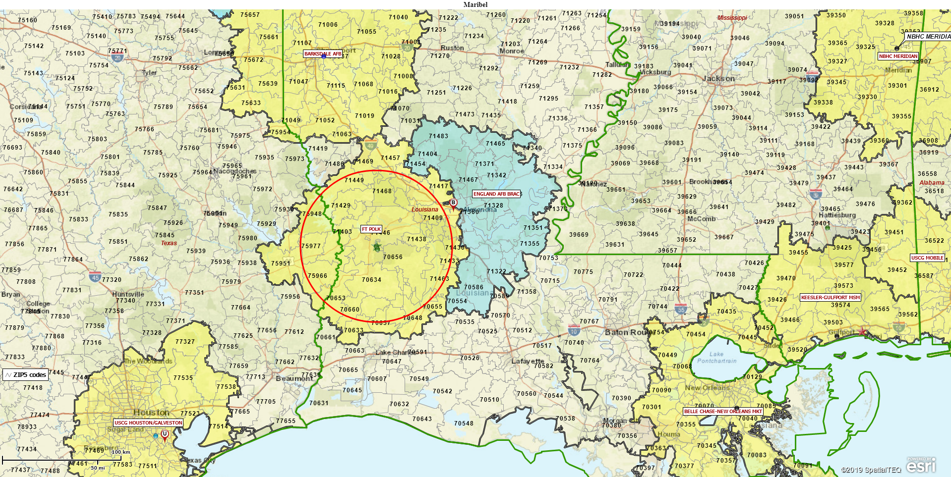
Her maps were both informative and beautiful. This MapBusinessOnline user places a 40-mile radius circle on a map area to reflect a hospital system’s general coverage area around the central address. Next, she often draws another circle with a 40-mile radius overlapping the original circle. This is to expose areas outside of the hospital coverage area and differentiate those areas from inside the original 40-mile HMO coverage circle.
Appreciating Map Clarity
What I liked about her map was its clarity. The purpose of the map was clear. The colors of the map were understated which further emphasized the map’s intent. The mapmaker used her own choice of color for unshaded ZIP codes, as opposed to the Map Business Online default colors. We’re not always right – think for yourself and for your map. I believe she used a very transparent pale yellow, which tends to serve well as a background color.
Maribel’s territory boundaries were carefully colored a dark shade, and not too thick. They are darkened just enough to highlight the critical HMO system territory areas. I asked her to tell the specific color she chose. She wrote, “Map & Data: check Line box (color= 999999), transparency=50% then uncheck fill box.” Business mapping can be detailed. I love it.
I also liked her logic. She used 40-mile radius because it reflected actual insurance coverage rules applied by the armed forces to their network of service people. Each HMO’s are responsible for armed services healthcare within a 40-mile radius of the major hospital locations. As you might imagine, Congress and the various military branches have all sorts of rules around requesting and receiving healthcare. Maribel expertly crafted several key maps that visualize these rules.
MapBusinessOnline offers a variety of shape creation tools or map object tools designed to produce a variety of shapes on the map and color fill them with appropriate and differentiating shades. By experimenting with a variety of colors, and border thicknesses the map creator will discover there are optimum map views to present to their map audience. Specific map views, with understated colors, carefully chosen map object boundary thickness and shades, will make your map stand out. Your maps will be viewed as more effective and more professional.
Give Your Labels Some Love
Another map element applied subtly by Maribel and that deserves a map creator’s careful attention, is labeling. Labels existed to identify ZIP codes, counties, states, and territories. A critical step in map making is taking the time to decide which labels are most important to include on your map. Too many labels can make the map too busy, distracting from the map’s purpose.
Our map creator, in this case, chose to use ZIP code labels and to make them bold, non-italicized, and black. ZIP codes were the important elements to her health insurance map, so she chose to label them boldly. It made sense to give them prominent placement. It added value to the map.
For centuries cartography and map-making skills were restricted skillsets, available only to trained cartographers appointed by royalty or the Christian Church. Maps were state secrets. Mapmaking was half art and half science, although, during the Church era of the middle ages, science was abandoned in favor of God. Remember those Jerusalem centric maps of the world? (Me neither.)
Today, almost anyone can access advanced map-making tools such as MapBusinessOnline, or more advanced GIS tools like www.esri.com. I say, “Go for it.” Just make sure you apply some thought and creativity like Maribel Roman.
We recommend users access MapBusinessOnline via the downloadable Map App.
The Map App install is fast and easy. The Map App is a cloud-based service, once you’ve logged in you’ll have access to all of your previously saved maps and data. The Map App is a better user experience and provides access to more features than the Web App. The Flash-based Web App link will remain available until December 15, 2020.
The Map App includes the new Map Viewer app for free non-subscriber map sharing.
Value-Added Resellers – Offer the tool to your customers as a reseller. Make money on training and consulting. Contact us with further interest in reselling Map Business Online.
Win a $20 Gift Card! Refer a business associate to Map Business Online in exchange for a $20 Amazon Gift Card!
America’s best geo mapping software.
Find out why over 25,000 business users log into www.MapBusinessOnline.com for their business mapping software and advanced sales territory mapping solution. The best replacement for Microsoft MapPoint happens to be the most affordable.
Discover Map Business Online – tools for making business maps

