Creating and editing territories is a core feature of MapBusinessOnline. First-time users should begin by creating a territory using a polygon search tool.
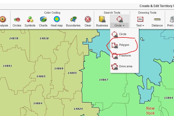
I suggest using this approach first because it gives the user a more visceral experience creating a territory. Select the Polygon option from the Search Tools section of the Master Toolbar. You’ll see the dropdown arrow – click that arrow and select Polygon. You could also try the Free Form selection tool. I happen to prefer the Polygon search tool for territory creation.
While the user can choose to create territories using one of many map layer alignment options let’s build our territories on ZIP5 codes for this exercise. Each MapBusinessOnline territory is based on one map layer. You cannot mix ZIP codes and Counties in one territory.
In Map and Data, make sure the ZIP code layer is checked on. Then, along the Master Toolbar, look for Search Tools. There, dropdown to select the Polygon search tool. Place your cursor on one of the ZIP codes you intend to include in the territory. Then hold down the cursor button and drag a line through the ZIP code you want to include. Each ZIP code you touch with your line will be included in the territory.
As you drag the line, stop, lift your finger, and press down again to begin in a new direction. Continue this lassoing of ZIP codes until you drag your line back to the very beginning. When you reconnect your line to the beginning, the shape snaps to a full polygon, and several dialog boxes pop open:
- In the ‘Search Data‘ box that appears, select the map layer of choice – in our example, it would be ZIP5 codes.
- With the Map Layer selection made, the ‘Create or Edit Territory‘ dialogue requests a territory name. Name the territory and click Create.
- With the territory now displayed on the map, and the Data Window Analysis view will pop open.
- To adjust the analysis view in Map and Data, click Choose Column in the lower right. Read more about the territory analysis options here.
Basic Territory Edits
Your new territory is now created. Select the Label and click Edit Properties to adjust the territory name, color, and territory labels. Read more about territory label editing here.
You can adjust the look and feel of the territory you’ve created. This will establish one look and feel on all further ZIP code territories in that map. Look and feel adjustments are made in Map and Data. Hover over the Territory Layer and click the Edit Map Layer Properties button.
The General tab opens, and you will find tools for the following adjustments:
- Territory Outline controls for thickness and color. In general, keep territory borders dark
- Hide Internal Boundaries – This button would make the ZIP code boundaries internal to your territory disappear. Hide Internal Boundaries is an effective clean-up tool to make your territories look cleaner, less cluttered
- Transparency Scroll Bar – Move this scroll bar control to the right to make the territory fill more transparent. Adjust to your personal preference or to differentiate the territories from background map objects
- Color Code Territory Layer – Click to color-code territories by demographics or imported data
- Manage Calculated Data Columns – Not something a first-time territory creator needs to worry about – Read more here.
The above process is the manual way to create and optimize territories in MapBusinessOnline. Understanding of this fundamental process, a MapBusinessOnline user can then move on to selecting territories incrementally (a mouse click at a time, holding down the shift key) or importing a territory spreadsheet. An imported territory spreadsheet should look like one of the below options:
| ZIP Code | Territory Name | Other Data | Other Data |
| 01966 | Franchise 1 | Abc | Abc |
| 01986 | Franchise 1 | 123 | 123 |
| 01975 | Franchise 2 | Abc | Abc |
Or for counties
| County | State | Territory Name | Other Data |
| Essex | MA | Franchise 3 | Abc |
| Essex | MA | Franchise 3 | 123 |
| Carroll | NH | Franchise 4 | Abc |
With your spreadsheet saved, click the Create Territories button, and follow the step-by-step dialogue process. Read more about importing territories here.
Varying Approaches
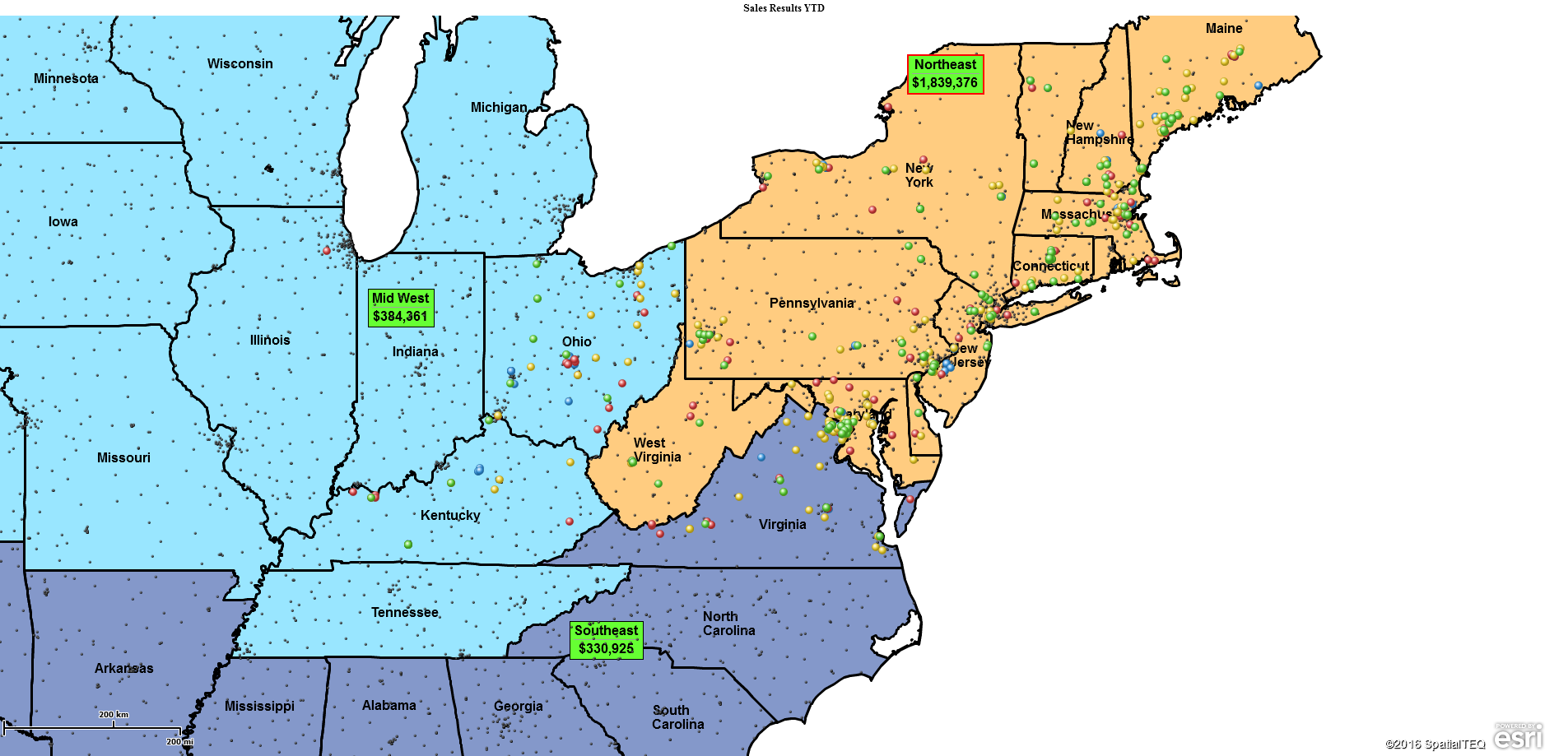
MapBusinessOnline territory managers can get creative in the way they approach territory management. For instance, a map creator can label their territories creatively:
Sales Organizations may have an interest in naming their territories by the designated sales rep. If Phil Raymond is responsible for a territory, then it makes sense to call it Raymond Territory or even Ray 1 for short. Sales commission calculations and progress against goal can be tracked through the territory process.
Franchise Organizations sometimes name their territories after the area represented geographically. The name of the territory becomes descriptive and can help sell the franchise area.
Insurance Companies have created claim territories named after their associated risk factor. Traveling insurance claim adjusters might assign Area RF-85 for an 85% risk factor. Identifying high risk by area of interest or territory can be a quick visual representation of risk.
Manufacturers, at times, will design their territories around product categories. The territories could be named after a sales rep or a distributing organization. Each product-gets a set of national or regional territories. The overall business view includes marketing budgets, sales forecasts, and eventually sales progress against goal.
Urban vs. Rural Territories
Territory managers will vary territory alignment structures as area characteristics shift from urban to rural settings. Inner city and suburban territories are generally ZIP code-based. As the business expands into more rural areas, more driving is required. Territories encompass smaller populations. In these more spread-out areas, county-based territories may be more appropriate.
Businesses that may need to consider varying map alignment layers are field staff management organizations and retail chains that cater to urban and suburban customers, like True Value Hardware or General Dollar. As territory and market analysis move from city to town, counties carry more weight than ZIP codes.
Other factors impacting territory creation approaches include:
- Coverage areas – Regional or local territories vs. national territories
- Sales strategies – Online sales, retail sales, direct mail sales, franchise sales
- Field staff requirements – Clinical, sales, or technical support
Additional Reading
To explore more territory considerations, and options read these articles:
- Tips for First Time Users of MapBusinessOnline
- A Word About Territory Mapping
- Guidelines for Territory Mapping
- 3 Key Aspects of Sales Territory Decisions
_______________________________________________
Find out why over 25,000 business users log into www.MapBusinessOnline.com for their business mapping software and advanced sales territory mapping solution. The best replacement for Microsoft MapPoint happens to be the most affordable.
To access MapBusinessOnline, please register and then download the Map App from the website – https://www.mapbusinessonline.com/App-Download.aspx.
After installing the Map App, the MapBusinessOnline launch button will be in the Windows’ Start Menu or Mac Application folder. Find the MapBusinessOnline folder in the Start Menu scrollbar. Click the folder’s dropdown arrow and choose the MapBusinessOnline option.
The Map App includes the Map Viewer app for free non-subscriber map sharing.
Please read customer reviews or review us at Capterra, or g2crowd
Contact: Geoffrey Ives geoffives@spatialteq.com or Jason Henderson jhenderson@spatialteq.com


