
MapBusinessOnline is perhaps best known for its territory mapping capabilities. These capabilities are fundamental sales and marketing tools for hundreds of thousands of businesses worldwide, including franchise, sales, and service organizations.
Many old-timer clients compare the capabilities of MapBusinessOnline territory management to those of Microsoft MapPoint—a product Microsoft abandoned ten years ago.
MapBusinessOnline stands out among business mapping software by integrating database management with handsome geographic map views and location-based data analysis. This unique combination of powerful data visualization tools makes it a wise investment for any sales and marketing or general business professional.
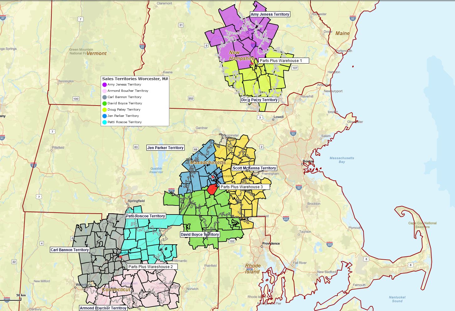
Three ZIP code-based drive times territories created using MapBusinessOnline.
Territory mapping users apply these location-based tools to many specific applications, including:
- Franchisee territory map development for area definition and contractual records.
- Field staff management for sales, clinical, homecare, and service industries.
- Market analysis in support of business expansion.
- Sales planning, forecasting, and sharing maps for business meetings.
- Support nationwide businesses with hierarchical territory maps for nationwide conglomerates.
Common
When map creators launch MapBusinessOnline territory mapping tools, they tend to do the following:
Build a ZIP code territory map of their area of interest – Map creators are generally more comfortable with ZIP code map layers for territory map creation. ZIP codes provide the geographic granularity required to manage their operations, especially for more regional and local businesses like franchise organizations and home care agencies. Multi-state territories do occur, but business life is often more complex than a state map layer allows at a geographic level. Learn more here.
Overlay imported customer or patient data—It is easy to import an address or latitude-longitude spreadsheet onto a MapBusinessOnline territory map. Customer layers add a visual component to the territory map and a datasheet view where customer locations can be geographically associated with other relevant data columns. Learn more about customer maps.
Create a demographic layer on their territory map. MapBusinessOnline includes access to the Census Bureau demographic data library for use within any business map. While the category options are extensive, territory map creators tend to pull from certain data types—population, income, ethnicity, and consumer expenditures are among the most popular. Learn more here.
Search for business listing sales leads to supplement existing customer locations – Prospecting for additional sales is a constant challenge for most companies. MapBusinessOnline lets the map user/creator search for new leads by business name, industry, ZIP code search, radius search, or polygon search. Fill in those canceled appointments or look for additional stops to fill out extended business trips. Learn more here.
Two New Key Features
Merge Existing Territories in One Step—Merging two distinct territories is often required when editing territories. Now, MapBusinessOnline includes a one-step Merge option to help the map editor quickly combine territories and decide what happens to the original territory selection. Select the territories you wish to merge and select Merge Territories in the dialogue box. You can choose to keep the name on one territory or create a new territory with your selection.
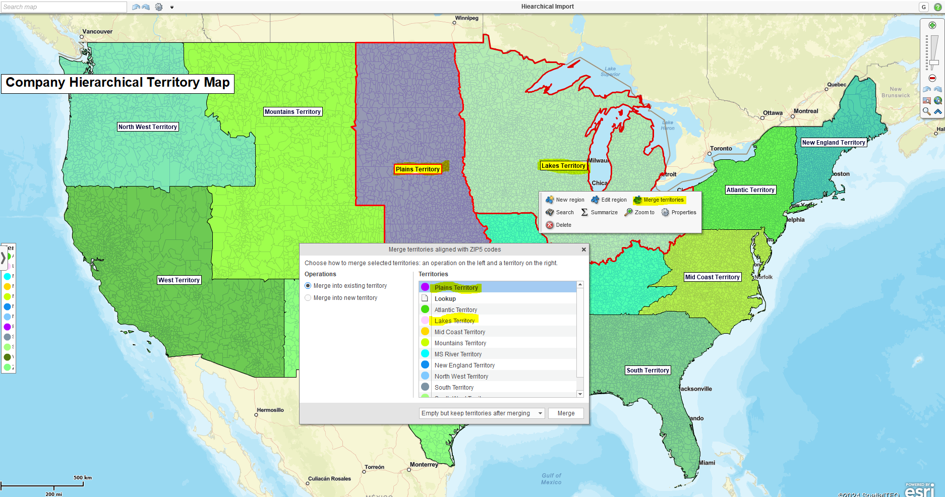
Select territories and choose the Merge Territories option.
Import Hierarchical Territory Spreadsheets – Our most recent territory enhancement. Create tiered territory hierarchy spreadsheets and import Territories, Regions, and Divisions in one step. You won’t believe how easy it is once you create your scheme. Learn more here.
Other Territory Mapping Functions
Edit & Optimize a Territory Map—MapBusinessOnline makes it easy to adjust the various visual components of an accurate territory map. Turn ZIP code and county layers on and off. Adjust layer transparency. Color-code the fill and boundary lines. Make your map more focused on critical elements such as core business targets.
Add additional data to Territory Map Labels – Sometimes, territory labels need to say more than just a name. MapBusinessOnline provides five flexible fields for territory labels, just like other map layer labels. Add imported numeric data or select demographic data to append to your territory labels. Additionally, there is a field for notes associated with every territory. Use the notes field to add information your constituents may require to do their job.
Share territory Maps with Constituents – Use MapBusinessOnline public map sharing to share view-only, pan-and-zoom interactive maps with constituents. They view, download data, and create routes, but they cannot edit the map. Learn more here.
Analyze a Target Market Area Using Territory Map Views – Using the territory map Data Window view map, creators can display the ZIP codes or Counties where they’ve been successful at selling. Add to this data view the demographic characteristics of those areas of interest, and a picture begins to take shape describing the most lucrative ZIP code types for certain products and services. Now, search the country for similarly populated sections and generate more business.
Additional Features Included in MapBusinesOnline’s Complete Territory Mapping Solution
- Filter the map view by area, ZIP code, county, state, and other map layers.
- Create optimized vehicle routes with up to 150 stops per route.
- Build up to 50 territory maps (Standard) or 1500 territory maps (Pro.)
- Color code geographic areas or imported location points.
- Share low-cost interactive maps. Generate PDF, Jpeg, KML, or PNG image files.
- Conduct advanced driving time and distance queries across datasets (Pro.)
- Generate spatial searches of data by radius, polygon, or driving time search.
- Export search results to CSV file – imported data, ZIP codes, demographic data, and business listings.
Testing comments functionality as part of smoke test for release 7.35.2.0.74148 and 7.35.3.0.74156. Support team, please respond to make sure it works. Thanks!
It works.