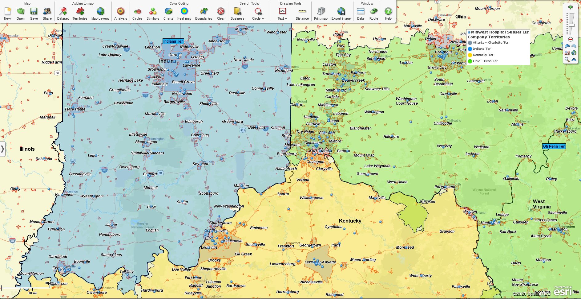
How AT&T, Asurion, L.L.Bean, and MapBusinessOnline Rescued My Cell Phone

I live in Maine. No spring chicken; I am relatively active for my advanced age.  And as a model Baby Boomer, I’m unsurprisingly tied to my cell phone. The thing provides all sorts of features I can’t live without, despite having lived without them for fifty-five years previous to my current iteration.

Like many aging Mainers, after July 5th, I get cold. So, killing a couple of birds with one stone, I wear an L.L. Bean fleece sweater to keep me toasty and to holster my phone. The fleece sports a zippered breast pocket for my precious cellular phone.

The breast pocket is my favorite feature of an L.L. Bean fleece. Unfortunately, it’s not foolproof. It satisfies the requirement that my phone is at the ready, so I never miss the next life-changing phone call – generally, a spam call from Michigan or some other faraway land warning me about my rapidly approaching mattress warranty expiration. But the fleece pocket doesn’t ZIP up automatically.

It’s incredible how often a cell phone can make the jump from my fleece breast pocket to the floor and not crack. It’s got to be a hundred times. And never once into the toilet. But this record of no significant screen cracks only serves to lull me into a state of false security. A month back, with my fleece pocket zipper wide open, I leaned over a granite stone protruding from the foundation of my home. Out popped my precious phone with its myriad of life-critical apps, and before you could say, ‘Bobbie Gentry’s my aunt,’ I had two 38-caliber bullet holes in my phone’s screen.

The fleece, the pocket, and Skye (the Yorkie).

At first, I thought I could live with it. I could still read most of my depressing top news content in and around the two puncture wounds on my screen. But after a while, with occasional tiny glass slivers in my fingers, and my news feed confused as to whether or not Trump’s alleged voter fraud was a big lie or just a little white lie, I decided I should explore a fix.

My first stop was the Magic Trick Cell Phone Repair shop. I’d been driving by this storefront for years. But Magic Trick wanted $285 to fix my Galaxy S9+. Some trick. In shock from the steep repair quote, I paused the whole project for a few weeks, carefully weighing my options before I waded back into the repair circuit.

I used MapBusinessOnline.com business listings to look for additional cell phone repair shops in the Portland, Maine area, but none of them seemed any more affordable than Magic Trick.
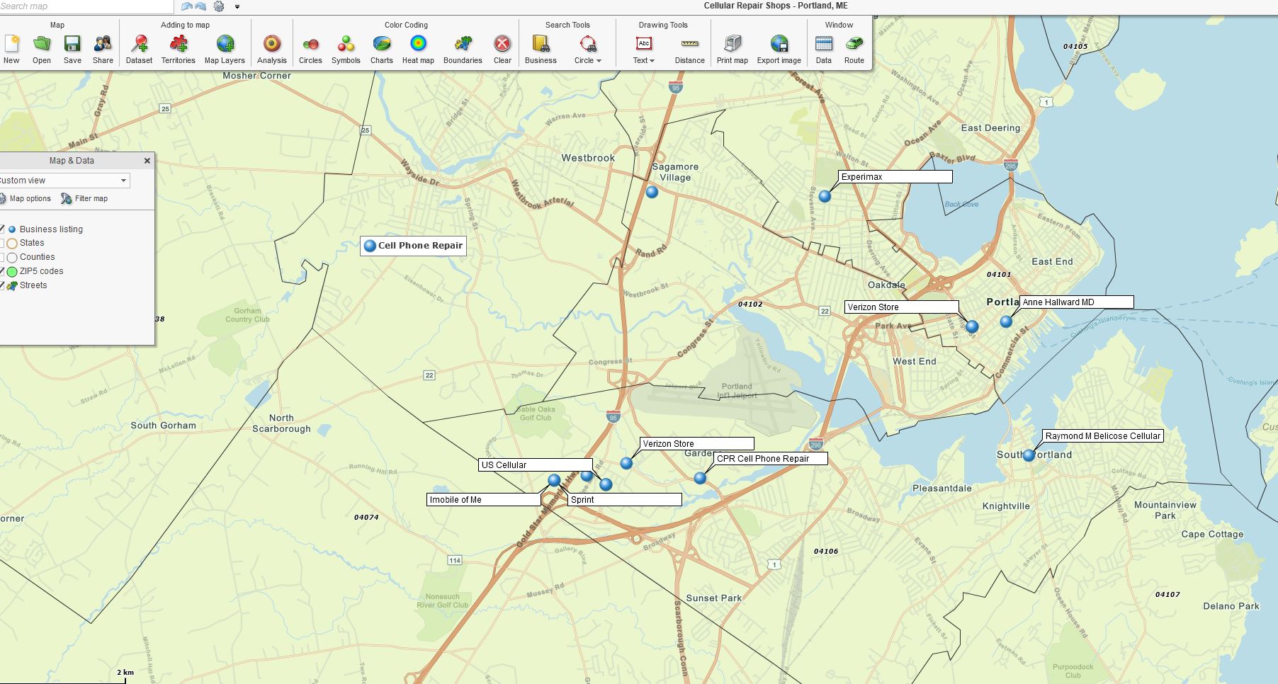
Cellular Repair Shops, Portland, ME

My oldest daughter, much more phone savvy than I, strongly suggested I take the phone to the Maine Shopping Mall, a place I avoid, like an in-law convention. I only go to ‘the Mall’ out of complete desperation. The place has sounds and smells that set off my brain’s fight-or-flight response.

But on one particular day, I was driving by ‘the Mall’ anyway and took a deep breath, put a close pin on my nose, parked my car, and crept in. My phone contract is with AT&T, so I headed that way. Right next to the AT&T store was a cell repair place.  They quoted me $200 for the fix, with a forty-five-minute wait. I said I wanted to check AT&T first.

Enter Asurion

The AT&T guy looked over my cellphone screen with its vampire bites and pulled up my contract. “You’ve got insurance coverage with Asurion,” he said casually.

I was stunned. “Really?” I asked in disbelief.

“Yup, here’s a website where you can make an appointment for Asurion to manage the repair for $30.”

What was this, Christmas in September? I felt like my estranged, wealthy but creepy hermit uncle had died and left me as his sole heir. (I don’t have an estranged uncle, but it felt like that.)

I was further surprised because Asurion was a company I was familiar with. As you know, I sell business mapping software professionally, Www.MapBusinessOnline.com. We do a lot of business in the insurance industry, providing sales territory mapping, customer mapping, demographic mapping, and location-based market analysis tools.

I remember when Asurion first purchased a MapBusinessOnline subscription. I had looked up their website, not entirely understanding their play in the cell phone business. Cell phone insurance? Huh?

Now, standing at the AT&T cell service table with my pathetic, broken phone and my sporty 2-year-old fleece sweater, I totally got it. Cell phone insurance. What a concept!

The Fix

The process for cell phone repair through Asurion was pretty straightforward. I registered online at www.Phoneclaim.com.  Once registered, the process led directly to verifying my AT&T contract and then to a ZIP code search where the repair contractor’s location was identified.

In my case, I had to bring the phone to an Asurion service tech in Portland – http://tardiffelectronics.com/. The process was fast – twenty minutes. It was also easy. The marginal fee of $30.00 was included in my AT&T monthly bill, which ended up $50.00 higher than usual, but it still beat the $200 plus repair quotes I’d been taunted with.

Best of all, I now own a phone with a new screen with zero bullet holes and no cracks. What had previously been a choice between losing $285 and impaired doom-scrolling for the rest of my days turned into a $50 idiot fee in exchange for a squeaky new screen.

I was thrilled. Asurion had indeed saved the day.

I’m still trying to get Asurion to speak with me about their specific use of MapBusinessOnline. But I know that insurance companies, in general, use MapBusinessOnline to create business maps describing the critical market and operating areas.

  • Claims Territories – Field claims processing groups often create business maps that assign and track incidents across a team of claims agents.
  • Identify Sales Coverage Gaps – Insurance companies track sales teams like any other large organization, analyzing sales coverages, competitors, and possible new market areas.
  • Track Claim Activities – Monitor contractor services at specific claims sites. MapBusinessOnline provides a map-based platform for visualizing contracted services by ZIP code, County, or City limit.
  • Sales Territory Mapping – Insurance companies monitor sales territories associated with the sales teams and field staff like any other large enterprise.
  • An Insurance Case Study – Read about insurance applications for MapBusinessOnline.

I share this phone repair experience to remind people to check with their cell phone service provider before proceeding with expensive cell phone repairs. You may already have insurance to cover most of the fix.

_______________________________________________

Discover why over 25,000 business users log into www.MapBusinessOnline.com for their business mapping software and advanced sales territory mapping solution. The best replacement for Microsoft MapPoint happens to be the most affordable.

To access MapBusinessOnline, please register and download the Map App from the website – https://www.mapbusinessonline.com/App-Download.aspx.

After installing the Map App, the MapBusinessOnline launch button will be in the Windows Start Menu or Mac Application folder. Find the MapBusinessOnline folder in the Start Menu scrollbar. Click the folder’s dropdown arrow and choose the MapBusinessOnline option.

The Map App includes the Map Viewer app for free non-subscriber map sharing.

Please read customer reviews or review us at Capterra or g2crowd.

Contact: Geoffrey Ives at geoffives@spatialteq.com or Jason Henderson at jhenderson@spatialteq.com.

Posted in A story, Business Mapping Software blog post | Tagged , , , , | Leave a comment

MapBusinessOnline Franchise Territory Map Creation Workflow

Franchise sales organizations use business mapping software to design, sell, and manage franchisee sales territories. MapBusinessOnline sales territory maps promote the sale of franchise packages to potential investors by accurately defining sales areas and providing transactional records backing up any franchisee investment.

MapBusinessOnline business mapping tools support Franchise Territory Management requirements on three levels:

  1. Franchise Territory Design – Providing an affordable, full-featured sales territory design toolkit. MapBusinessOnline franchise territories are easy to create and manage. The geographic territory tools address critical franchise issues such as eliminating overlap and territory sales equity.
  2. Franchise Territory Documentation – The ability to generate balanced franchise territories based on critical demographic and end-user sales data. Franchisee territory valuation reports and compelling territory map visualizations define and justify the franchise investment. Map visualizations and analysis views also serve as marketing documents and franchise purchase records.
  3. Franchise Territory Availability – MapBusinessOnline territory map visualizations provide structure for the franchising organization to display available and sold territories by shared, color-coded map visualizations.

Create Franchise Territories Based on Relevant Metrics

Consumer-focused franchise organizations construct balanced franchise territories based on relevant demographic characteristics. Franchise companies use MapBusinessOnline to import and compile critical demographic and sales activity data as territory analysis views.

Territories are aligned on ZIP codes, counties, or city limit map layers, offering standardized and balanced sales opportunities for prospective franchisee review. MapBusinessOnline US Census Bureau demographic libraries are tapped for relevant population, income, or consumer expenditure data during the territory creation process.

The territory creation  process follows standard MapBusinessOnline workflows:

  1. Create initial optimum geographic areas of franchise operation by map alignment layer. Territories are designed by:
    1. Driving time or distance calculations using city limits, ZIP codes, or counties.
    2. Radius or polygon search areas using city limits, ZIP codes, or counties.
    3. Incremental Zip code or county selection.
  2. Determine optimum demographic categories for equitable franchise valuation and balancing. One or two demographic categories are typically applied for balancing:
    1. Primary – Population segments by age, ethnicity, income, or another relevant category.
    2. Primary – Sales and marketing projections by area.
    3. Secondary – Relevant Census consumer expenditure categories.

MapBusinessOnline provides multiple options for selecting the optimum territory size. Territory areas can be defined by driving time or distance calculations. Radius searches covering population centers also make reasonable territory size and valuation starting points. Simple incremental ZIP code selection is another approach that can organize territories into equitable franchise areas.

Territory creation approaches vary by industry, product, or service type. Common territory approaches by industry include:

  • Retail industry product sales – Create territories by ZIP code gathering or consumer drive time tolerances.
  • Repair services – Create territories by county or ZIP code gathering by radius search or technician driving distances.
  • Services in the home – Create territories by city limits and driving time estimates.

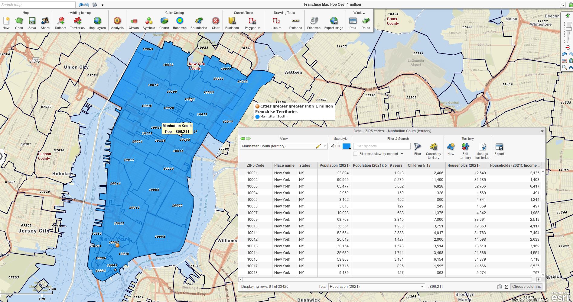
Manhattan South Franchise Isolated View with Datasheet

Getting Started Building Franchise Territories

Franchise organizations explore possible franchise territory scenarios using their knowledge about markets and known areas of franchise interest. MapBusinessOnline territory management tools enable initial physical boundary trials by ZIP code, County, City limit, or Marketing Statistical Areas. To begin:

  1. Create several territories in well-understood areas.
  2. Balance sales data appropriately for fair and equitable franchise market values by territory. Use primary demographics, sales, and marketing data to value and balance initial territories.
  3. Roll out additional territories as interest develops and early franchisee adopters gain a foothold.

Franchisers begin the territory development process in well-understood areas. Franchisee feedback is collected as territories roll out to adjust demographic or sales allocations as necessary. Be flexible in the initial stages of franchise map development.

Controlling Overlap

MapBusinessOnline includes a control button for Overlapping Area Identification.

  1. In the application, go to Map and Data and open Map Options.
  2. Se lect Territory Options
  3. Check on the Intersection controls.
  4. Click the Intersection Tab to adjust the overlap color shading.

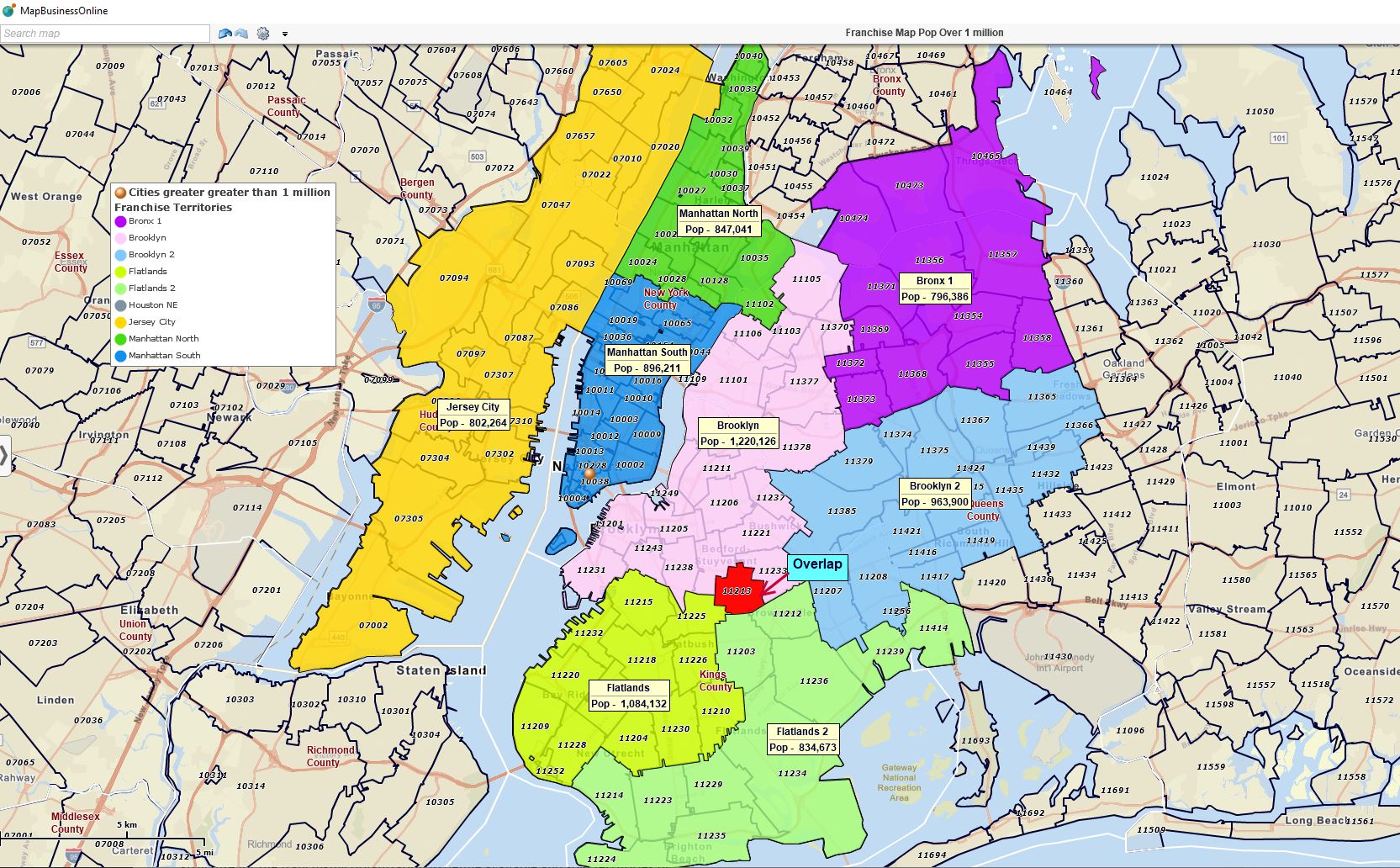
Now any overlapping ZIP codes or counties will show up in bright red or a user-defined color, keeping franchise territories well-defined, with no overlap.

NYC Franchise Map Development Targeting 800,00 to 1 million Population Segments

Franchise Territory Color-Coding

MapBusinessOnline Sales Territory Management tools provide map visualization and analysis views. Read more about sales territory construction here.

With territories created and named, franchise territory managers can view the list of available territories in MapBusinessOnline’s Data Window view. This view includes access to database views with the following:

  • Imported sales location data
  • Relevant demographic data layers as assigned.

The franchise territory maps themselves become a sales and marketing tool. All territory maps can be shared via non-editable password-protected map share links. Or generate image files for emailing and presentation graphics. Read more about public map sharing here.

Franchise territory owners often color-code their territories to reflect sold and available status. Color-code schemes could also reflect sales projections by territory or demographic characteristics. For example, the map may show all sold territories as a shade of red. All available territories show as Green.

Color-coding schemes are industry specific. For instance, some industries require franchise trial periods which would introduce a new status classification color option.

Generate Franchisee Investment Records

Franchise sales organizations require map visualizations outlining the geographic extent of any franchisee-purchased territory and a datasheet outlining the potential sales for an area. MapBusinessOnline franchise mapping provides franchisee map visualizations and a datasheet view describing the territory investment.

Once territories are created in MapBusinessOnline, click the Save button and save the complete territory map project as a My Template map. Templating protects all parent franchise map work from inadvertent overwriting.

Use MapBusinessOnline to create isolated views of individual franchisee territories. Follow this process in MapBusinessOnline:

  1. Select the Territory layer in the map layer drop-down on the left in the Data Window.
  2. Under the Filter and Search section of the Data Window toolbar,
    1. Key in the name of the Territory under consideration for purchase.
    2. Click the Filter icon to the right of the search box.
    3. Check the Data Window Toolbar box labeled “Filter Map View by Selection.”
    4. Click the Spreadsheet Icon in the Territory data layer to open the individual territory datasheet view.
  3. The Map view now displays the franchise territory under discussion. Click the Save button and save the Map as a My Map project. The kept My Map map project is a permanent record of this franchisee investment.
  4. Generate images and datasheet views from the saved map for sharing with investors.
    1. Save image files as Jpegs, PDF, or PNG files which can be emailed or printed.
    2. Export the Data Window view of individual franchisee purchases as a datasheet view with demographics, sales potential, and other relevant data included using the Export button on the Data Window toolbar. Territory data is exported as CSV files.

Once the franchisee has all the relevant documentation, file copies with each franchisee’s file folder for future reference.

MapBusinessOnline provides all the territory tools required to support franchise sales for your organization. Leverage MapBusinessOnline sales territory management tools to drive your business forward locally, regionally, or nationally.

Review franchise-company case studies published on our website. MapBusinessOnline works with a growing list of franchise organizations daily, helping them sell and maintain territories across a variety of industries, including:

  • Child Support
  • Education Services
  • Elderly Home Care
  • Energy Delivery
  • Home Services
  • Residential Products
  • Manufacturing
  • Medical Services
  • Restaurant
  • Retail

_______________________________________________

Discover why over 25,000 business users log into www.MapBusinessOnline.com for their business mapping software and advanced sales territory mapping solution. The best replacement for Microsoft MapPoint happens to be the most affordable.

To access MapBusinessOnline, please register and download the Map App from the website – https://www.mapbusinessonline.com/App-Download.aspx.

After installing the Map App, the MapBusinessOnline launch button will be in the Windows Start Menu or Mac Application folder. Find the MapBusinessOnline folder in the Start Menu scrollbar. Click the folder’s dropdown arrow and choose the MapBusinessOnline option.

The Map App includes the Map Viewer app for free non-subscriber map sharing.

Please read customer reviews or review us at Capterra or g2crowd.

Contact: Geoffrey Ives at geoffives@spatialteq.com or Jason Henderson at jhenderson@spatialteq.com.
Posted in Business Mapping Software blog post, How to instruction, Sales and marketing | Tagged , , , , , | Leave a comment

Thematic Mapping Options Using MapBusinessOnline

Thematic maps are a common application of MapBusinessOnline. The business mapping software ingests a dataset of location points by address and selects a numeric column of data to color-shade a map layer such as ZIP codes or Counties. The numeric columns of data become the thematic coloring element for the map. The map viewer can quickly associate color-shaded ZIP codes or Counties with specific data trends complimenting the map’s intent.

Examples of data-appropriate thematic coloring columns are:

  • Monthly sales totals by account address.
  • Residential home values.
  • Hospital pandemic case counts.
  • Population by County map using demographic data
  • Median Income vs. homeless shelters by ZIP code

The data noted above is used to develop a data-based theme on a business map. Additional map layers are added to contribute to the overall value of the map project.

Read more about color-coding map layers:

Generally, thematic maps utilize the ability to color-code map layers, such as ZIP codes or counties, based on a column of data. But you could also color-code or size-adjust map symbols associated with address points on the map. Map visualizations can include a variety of map layers and color-coded schemes as long as the data presented is relevant and correlated. Random map layers can distract map viewers. Relevant data is critical to a successful business map project.

Thematic Maps Come in Many Shapes, Colors, and Sizes.

I mention this because I’ve found business mapping customers sometimes use one business map as a catch-all scratch pad for business issues. A designated map creator might start with a map of customers. Sales territory mapping soon follows. The next thing you know, vendor addresses are on the map, followed by hospitals, airports, and zoos. Pretty soon, the map is useless to all but a few ‘in the know’ map viewers.

Build Template Maps

A great way to avoid this cluttered map problem and maintain your original scratch map is to save all map work as a Map Template. When you click the Save Map button on the MapBusinessOnline Master Toolbar, you have two options for saving map views.

  • My Map
  • My Template.

Please get in the habit of saving My Map templates. The user opens their map project, adds more layers, and saves that new configuration as a My Map. You’ll always have that saved and worked-up template map – a worksheet, a territory map, or a base thematic map.

Tip: When creating or editing a map, you always have the option of saving the map you’re working on under a new name, thereby creating a new project. It sounds simple enough; remember to do it for work that matters.

Read more about map templates here.

Color-Code by Circle Layer

Point layers are imported business data from spreadsheets. Usually, an Excel Spreadsheet is overlayed onto the map as a point layer. These location data points are symbolized and color-coded using a column of numeric data. MapBusinessOnline provides four options for displaying point data layers, all listed under the Color-Coding section on the MasterToolbar:

  • Color-coded Points using the Symbols button.
  • Color-code by Circle using the Circle button. This option includes the ability to display an integer.
  • Charts and Graph symbols can be applied.
  • Point layers can be converted into a Heat Map layer.
  • Boundaries let the user color-code map layers like city limits, counties, and ZIP codes.

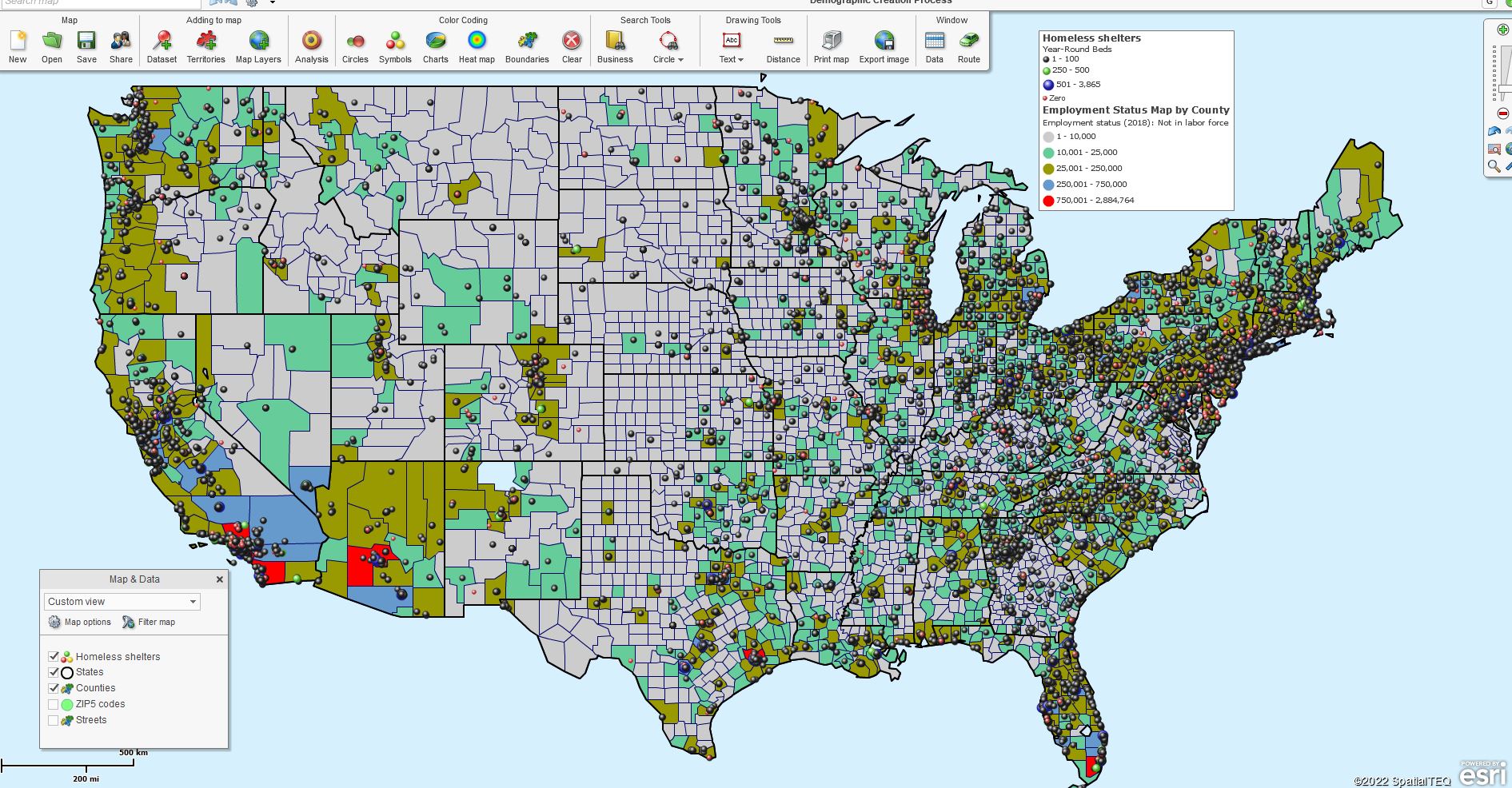
Consider these color-coded symbol options carefully when creating your business map. I generally use the Symbols button option. Symbols provide a library of map icons to choose from, but I find the colored dots are the best map visualization option. With Symbols, you can adjust:

  • The symbol set itself and import your own symbol sets.
  • Symbol color shades – there’s a color box for each symbol.
  • Symbol size – increase or decrease the size.
  • Numeric ranges are customizable up to 100 ranges.

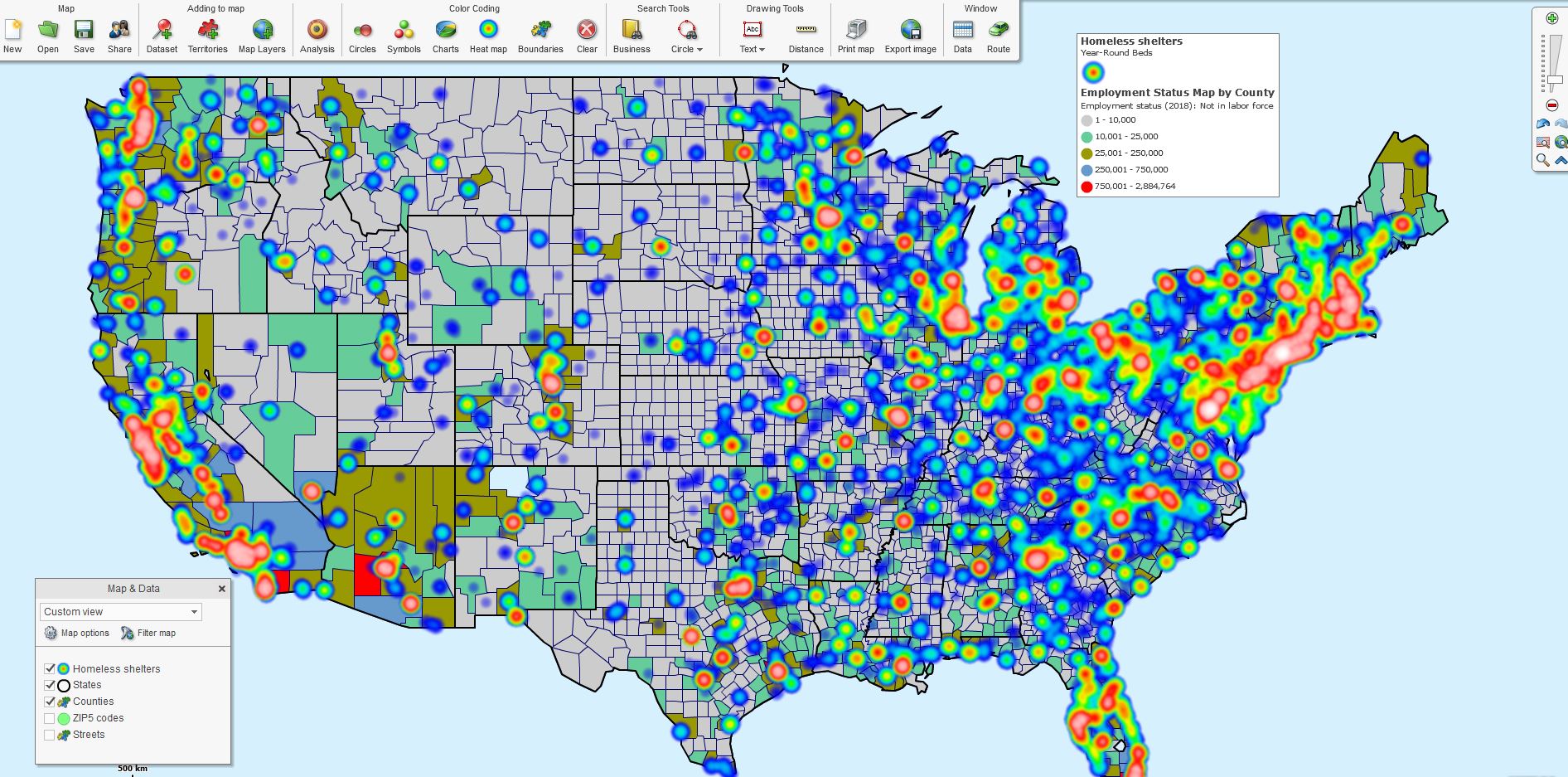
Employed Labor Theme & Homeless Beds Heat Map.

Employed Labor Theme & Homeless Beds Symbols.

Once any symbol scheme is selected, the Map Legend reflects that scheme. Click the small edit gear in the Map Legend’s upper right to adjust the legend lines’ look and feel. All content in the Map Legend is editable. Read more about the Map Legend here.

Color-code by Circle works similarly to Symbols, but you do have some additional options:

  • Choose which data later impacts color, size, and label.
  • Adjust the circle look and feel – color, border, 3D.
  • Choose to show numeric data on the symbol.

Charts and Graphs are handy for comparing year-over-year or month-over-month numeric results. So make sure your data reflects systematic comparisons by column before you use charts and graphs.

Add a Heat Map

Sometimes your data begs to reflect intensity on a business map. The MapBusinessOnline heat map button takes the numeric data columns from imported spreadsheets and transforms them into areas of more and less intensity. These weather-map-like overlays provide the map viewer with apparent regions of increased activity.

Heat maps display obvious and critical numeric data. Try out your data target and see if it’s the right fit for your map visualization.

Another heat map function is what we list here as Boundaries. You can click  Boundaries to color-code a map layer by your imported data column. Many map users refer to this application as heat mapping. Read more about heat mapping using MapBusinessOnline here.

The options noted above optimize your thematic map; to embellish your map story for your map audience. Other possible visual additions could include:

  • Adding a map object like a colored polygon or large radius circle.
  • Use the application as a live display or take pictures using the Snippet tool.
  • Placing text boxes, map titles, and summary data results on the map – read more here.

Thematic maps are commonly applied to demographic map projects. Demographic data, which is included with MapBusinessOnline subscriptions, make great thematic topics. Use a demographic thematic map as the background for your business data. Thematic maps can be very effective for business projects related to common demographic themes such as population, income, or other topics.

We used thematic mapping during the height of the Pandemic to display COVID -19 cases, deaths, and ultimately vaccination status by state. What fun!

So now, in our post-pandemic world, let’s find even more uplifting things to map about, like climate, international relations, or inflation. When is that passenger ship to Mars leaving?

_______________________________________________

Discover why over 25,000 business users log into www.MapBusinessOnline.com for their business mapping software and advanced sales territory mapping solution. The best replacement for Microsoft MapPoint happens to be the most affordable.

To access MapBusinessOnline, please register and download the Map App from the website – https://www.mapbusinessonline.com/App-Download.aspx.

After installing the Map App, the MapBusinessOnline launch button will be in the Windows Start Menu or Mac Application folder. Find the MapBusinessOnline folder in the Start Menu scrollbar. Click the folder’s dropdown arrow and choose the MapBusinessOnline option.

The Map App includes the Map Viewer app for free non-subscriber map sharing.

Please read customer reviews or review us at Capterra or g2crowd.

Contact: Geoffrey Ives at geoffives@spatialteq.com or Jason Henderson at jhenderson@spatialteq.com.
Posted in Business Mapping Software blog post, Sales and marketing | Tagged , , , , , , | Leave a comment

Combining MapBusinessOnline Features to Solve Business Challenges – Market Analysis

MapBusinessOnline Standard and Pro offer various business mapping tools that many companies use to generate map visualizations, navigate using optimized routing, build demographic thematic maps, and conduct map-based market analysis.

The list of business mapping software capabilities is extensive:

  • Batch Calculate distances and times between datasets.
  • Business Listings search.
  • Calculated data columns.
  • Collaborative map editing.
  • Concentric circle mapping.
  • Crime mapping.
  • Customer mapping.
  • Import and color-coded business location data.
  • Dot density mapping.
  • Draw tools for map object creation.
  • Demographic mapping and analysis.
  • Field staff management.
  • Find the nearest – Proximity search.
  • Heat mapping overlays.
  • Large format PDF printouts (Wallmaps).
  • Location database overlays.
  • Map-based market analysis.
  • Map print and image generation.
  • Map sharing.
  • Optimized vehicle routing.
  • Optimized map visualizations.
  • Personal mapping.
  • Political mapping.
  • Sales territories by region and division.
  • Sales territory mapping.
  • Thematic map creation.
  • ZIP code mapping.

I have written about all of these tools to some extent. This time I’d like to discuss how a user can combine three or more of these tools to solve a business problem.

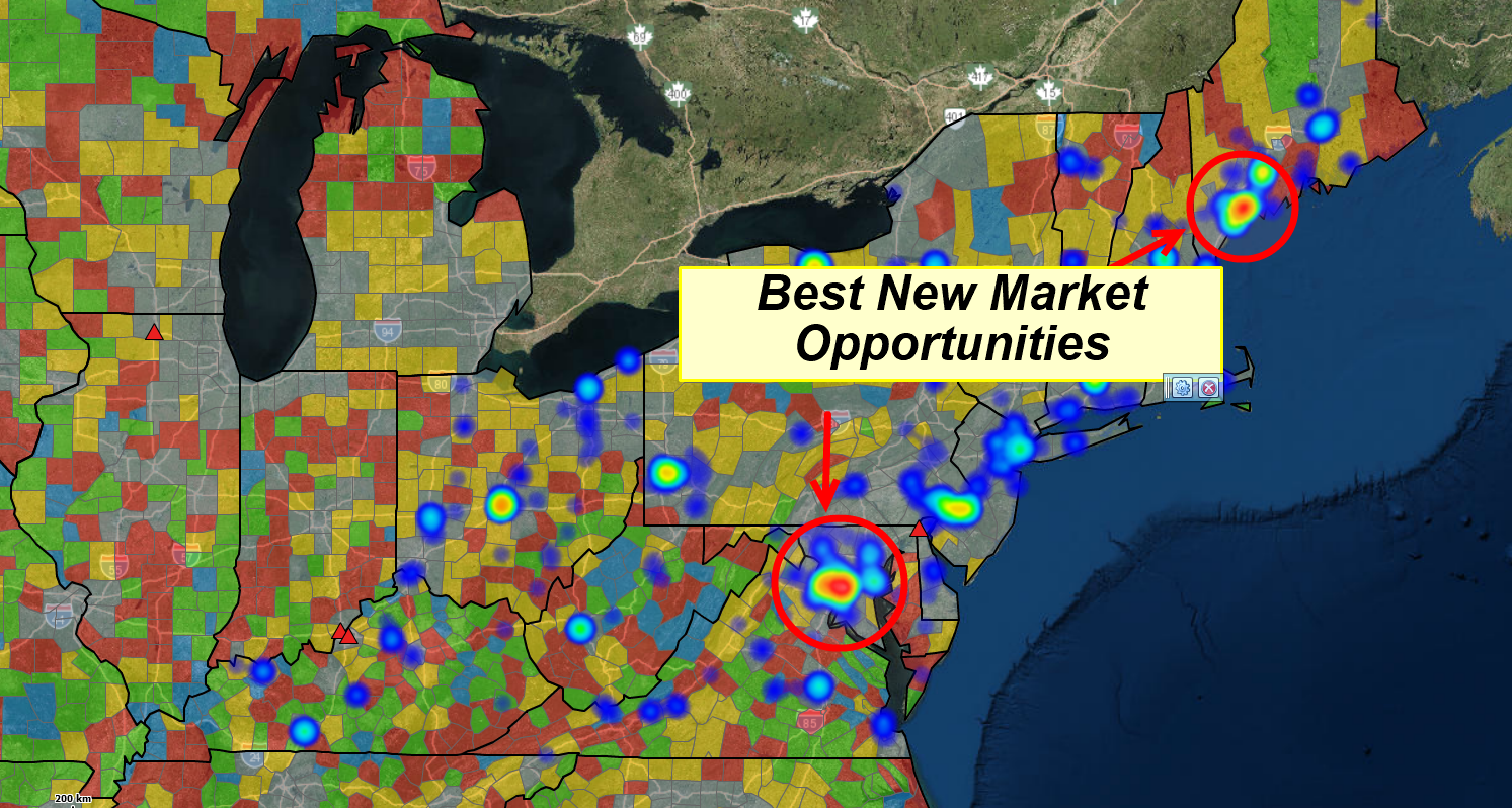
I am using MapBusinessOnline to identify market opportunities.

Map-based Market Analysis

It’s difficult to say when demographic mapping becomes full-on market analysis. Perhaps when the map creator taps three or more business mapping functions to create marketing studies.

It is easy to say that when a company requires market analysis, it’s generally indicative of growth problems, expansion challenges, or other sales and marketing-related obstacles.

Using MapBusinessOnline Standard, a comprehensive market analysis is generated for a given area or the entire nation. A great starting point is importing current or recent sales location data by customer address. Importing Excel spreadsheets with addressing is quickly done in MapBusinessOnline Standard or Pro. Pro enables the import of up to 250,000 records per map. Standard users are limited to 50,000 data points per map.

What you use for sales activity depends on what other information you want to include in your map project. Imported data can be visualized as ZIP code thematic maps or displayed as color dots of various sizes. Heat map views that turn imported numeric data into what looks like a weather map can also be an effective way to display sales activity. Always keep in mind the KISS rule of business mapping:

KISS – Keep it Simple Stupid.

Read more about importing your location data spreadsheets here. Complicated or cluttered maps lead to distracted map viewers and confusing map messaging.

Cluttered or informative? The Map Creator decides.

Include Demographic Mapping

Market Analysis maps are usually about business potential and sales growth. Consequently, for many businesses, the next MapBusinessOnlone feature to consider is Demographic Mapping.

Both MapBusinessOnline Standard and Pro allow the map creator to access demographic information from the Census Bureau and add it to the map view as both a map layer theme and a database layer.

Choose your demographic categories carefully. It’s essential to connect the selected demographic layers with your business in some way. Population and income levels are popular categories, but they could be irrelevant for some business analyses.

Retail business analysis will include population segments such as kids, the elderly, or women aged 25 to 50, depending on the products sold. Hot tub manufacturers may be more interested in examining higher median house income levels in affluent ZIP codes or Cities. My point – keep the core business focus and product offering in mind when generating demographic analysis.

Demographic data can be leveraged in various ways within MapBusinessOnline market analysis. The map creator should consider the options, keeping her map audience’s critical business interests in mind.

  • Which map layers would best demonstrate the most relevant demographic data? ZIP codes, City limits, or perhaps Counties?
  • Are there additional map data sources that serve the map well if referenced numerically in labels?
  • Or would an area Summary query added to the map add value for the map viewer?

With all of these options, think about your map audience’s perspective. Lay people may be overwhelmed with too much detail. A room full of MBA holders will want to see justification data.

Read more about labeling options here.

Map Layer Choices

The map creator should carefully consider which map layer best represents the business map’s ultimate goal. Do counties reflect your subject business better than Zip codes? Think it through. Perhaps your sales territories are based on ZIP codes. If that’s the case, then ZIPs are probably a better map layer for your analysis.

City limits are also a possible base map layer for your market analysis. If you are a retail chain with store placements at inner city locales, give the City Limits layer a try. I like City Limits for high median income level assessments. It’s a great way to filter by income levels to show the nation’s top twenty cities for your detailed analysis.

ZIP codes are better for identifying urban area demographic characteristics related to a product or service. Identify ZIP codes where sales and marketing efforts are performing well and gather vital demographic data related to your product or service for that ZIP code. Next, find similar ZIP codes in untapped parts of the nation.

Counties may be a better map layer for businesses selling in rural areas. Counties cover a broader scope of interest, gathering more consumer data for analysis.

Calculated Data Columns

I want to introduce one more beneficial tool for building market analysis – Calculated Data Columns. Calculated Data Columns are applied by the map layer. It allows the map creator to sum related demographic data layers into a single combination layer for use in Territories, ZIP code maps, and market analysis.

Use calculated Data Columns to sum similar demographic data segments. Examples include creating one calculated data column from:

  • Various population segments by age into one Elderly Population layer.
  • Disparate children population by age segments into one Kids Population segment.
  • The highest four median income levels into one Wealthiest Americans segment.

The Wrap Up

My point is to demonstrate that MapBusinessOnline Pro and Standard offer multiple features that provide advanced market analysis for sales and marketing teams or strategic planning.

The advantages MapBusinessOnline Pro provides over Stanard include:

  • Import up to 250,000 location points.
  • The Analysis Tab
    • Multiple Dataset Driving Time and Distance Queries.
    • Proximity Searching.
    • Batch Calculate Origin to Destination Pairs.
    • Enrich and Summarize Imported Business Datasets with Demographic and Geographic Data.
    • Create One-Pass Multiple Drive Time-based Territories.

Map creation and market analysis are natural partners in support of business planning. Take the time to explore some of MapBusinessOnline Standard and Pro features so that your business fully benefits from the power of location. Your company’s business trajectory and career path stand to gain from the exercise.

_______________________________________________

Discover why over 25,000 business users log into www.MapBusinessOnline.com for their business mapping software and advanced sales territory mapping solution. The best replacement for Microsoft MapPoint happens to be the most affordable.

To access MapBusinessOnline, please register and download the Map App from the website – https://www.mapbusinessonline.com/App-Download.aspx.

After installing the Map App, the MapBusinessOnline launch button will be in the Windows Start Menu or Mac Application folder. Find the MapBusinessOnline folder in the Start Menu scrollbar. Click the folder’s dropdown arrow and choose the MapBusinessOnline option.

The Map App includes the Map Viewer app for free non-subscriber map sharing.

Please read customer reviews or review us at Capterra or g2crowd.

Contact: Geoffrey Ives at geoffives@spatialteq.com or Jason Henderson at jhenderson@spatialteq.com

Posted in Business Mapping Software blog post, How to instruction, Sales and marketing | Tagged , , , , , , | Leave a comment

MapBusinessOnline Pro – Finding the Nearest Critical Locations

“How do you find a needle in a haystack? Use a wicked giant magnet.” – Early Maine wisdom.

But what if your ‘haystack’ is a reasonably sizeable location-based dataset? And perhaps your needle is a few address data points in another dataset? Well, that’s something MapBusinessOnlinePro business mapping software can assist with through robust geographic analysis and drive time queries.

Find the Nearest location(s) is a driving time and distance query that many businesses conduct to reveal the addresses nearest to other addresses. These queries are sometimes called proximity searches. Why would a company need to find the nearest facility or business locations? There are many reasons why including:

  • To identify which customers are closest to a retail store.
  • To determine how long emergency vehicles take to travel from patient locations to medical facilities.
  • To analyze the proximity of suppliers by driving distance from multiple manufacturing sites.
  • To assess the viability of a new business site based in part on the distances between competitor locations and the top twenty customers.
  • To expose additional customers or prospects for a traveling salesperson seeking to expand their contacts list.
  • To assess sales coverages for territory management

Businesses are seriously impacted by the proximity of facilities to constituents, be they customers, suppliers, patients, employees, students, or any other type of organization member. How close or far away a group of constituents reside can make or break the ability of a facility to be profitable or effective in its endeavors.

MapBusinessOnline Pro provides location-based analysis tools that compare existing or proposed site addresses to those of customer or constituent locales and generates a tabular analysis of travel times or distances between all points. The results show data location points and the distances or times between each set of points.

Find the Nearest Analysis Using MapBusinessOnline

Finding the Nearest

The tool the MapBusinessOnlin Pro dedicates to ‘finding the nearest’ addresses is called, wait for it, Find Nearest Locations. The tool is listed under the Analysis menu button on the Master Toolbar.

The map creator opens the Find Nearest Location function and proceeds with the following steps:

  1. Measure – Select an Analysis option from the below list:
    • Straight distance – as the crow flies.
    • Drive distance – fastest way along the road network.
    • Drive time – shortest time along the road network.
  2. Choose the location datasets to compare.
    • Customer location – field constituents.
    • Store or pickup location – facility location such as hospital, retail outlet, or police station.
  3. Choose a maximum distance or time option.
    • No maximum.
    • Enter the distance (miles or kilometers) or time in minutes.
  4. Enter the Text used as column headers in your output/reporting.
  5. You can choose to find up to 20 nearest stores to your location data.

Under step 1 above, MapBusinessOnline provides several analysis choices for finding the nearest target. A map user can select to find the nearest store (for instance) by:

  • Straight line distance – The direct distance as the crow flies, miles or kilometers, from point A to point B.
  • Driving distance – The most direct vehicle driving distance in miles or kilometers along the road network.
  • Driving time – The most direct vehicle driving time in minutes along the road network.

Organizations managing delivery vehicles, buses, and courier services will be interested in Find the Nearest analysis based on driving time or driving distances. Field tech services and direct mail services might find Straight Line analysis appropriate for estimating service fees by area or anticipated deliveries by ZIP 3 codes.

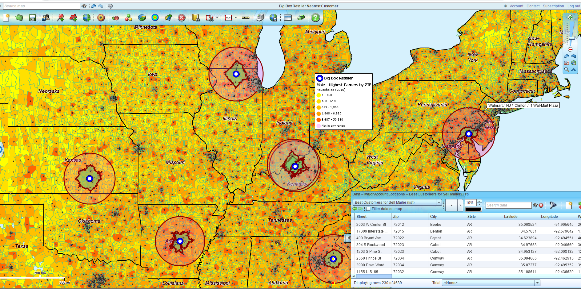
Competitor Map

Driving Distance and Time Find the Nearest

Finding the nearest customer seems to be the most popular application of the Find the Nearest query. Such customer queries are able to answer questions for sales organizations  servicing customers in a variety of ways:

  • Traveling salespeople regularly meet face-to-face with customers to coordinate orders, provide price quotes, or review upcoming requirements.
  • Deliveries of goods and services – Customer buy products and services and pay close attention to delivery times. Identifying the nearest twenty customers prioritizes customers for immediate or later delivery.
  • Retail customers often require a driving time estimate to entice them to store locations in shopping malls or busy downtown areas. Finding the nearest retail clients can trial customer experience workflows to match new retail locations or campaign launches.

An example I love to use is the beer supplier to a grocery store relationship because it represents so many business relationships:

  • Supplier of raw materials to a manufacturer.
  • Distributor supplier for end-users.
  • Wholesaler supplier for retailers.
  • Fuel delivery trucks deliver heating oil to residential homes.

In the Find the Nearest analysis in MapBusinessOnline, the map creator sets up the Grocery Chain facility as the Customer location and the Brewery supplier as the Store location. The query adds columns to the existing dataset views in the Data Window, showing distance or time and listing the top X stores closest to the customer. Or vice versa, as the case may be.

Results of the Find the Nearest calculations are tabular (like spreadsheets) and export out of MapBusinessOnline as a . CSV file. As an additional aid in analyzing the results, MapBusinessOnline provides easy filtering and sort options to help narrow down numerous result lines.

So figure out which of your datasets is a needle and which is a haystack and run a Find the Nearest query using MapBusinessOnline Pro to determine your closest pile of gold.

_______________________________________________

Discover why over 25,000 business users log into www.MapBusinessOnline.com for their business mapping software and advanced sales territory mapping solution. The best replacement for Microsoft MapPoint happens to be the most affordable.

To access MapBusinessOnline, please register and download the Map App from the website – https://www.mapbusinessonline.com/App-Download.aspx.

After installing the Map App, the MapBusinessOnline launch button will be in the Windows Start Menu or Mac Application folder. Find the MapBusinessOnline folder in the Start Menu scrollbar. Click the folder’s dropdown arrow and choose the MapBusinessOnline option.

The Map App includes the Map Viewer app for free non-subscriber map sharing.

Please read customer reviews or review us at Capterra or g2crowd.

Contact: Geoffrey Ives at geoffives@spatialteq.com or Jason Henderson at jhenderson@spatialteq.com

Posted in Business Mapping Software blog post, How to instruction, Sales and marketing | Tagged , , , , , , | Leave a comment

Easily Export All ZIP Codes Segmented by Territory

Earlier this year, I wrote an article declaring that ZIP codes are our customer’s preferred map layer for sales territory alignment. I stand by that assertion. Read the actual article here.

I’ve also penned blog posts describing the complex nature of ZIP codes. Read that article here. There are multiple ZIP code types, including boundary and point ZIP codes. Point ZIP codes represent significant single dropoff points for mail delivery, such as hospitals, military installations, or assisted living centers.

MapBusinessOnline includes a variety of features in our business mapping software dedicated to the glorification of ZIP codes. OK, maybe not glorification. But this isn’t a religious blog. And our online mapping service supports general business people, and general business people use ZIP codes all the time. So ZIP codes are important. Maybe not Quee Elizabeth I or II important, but important nonetheless.

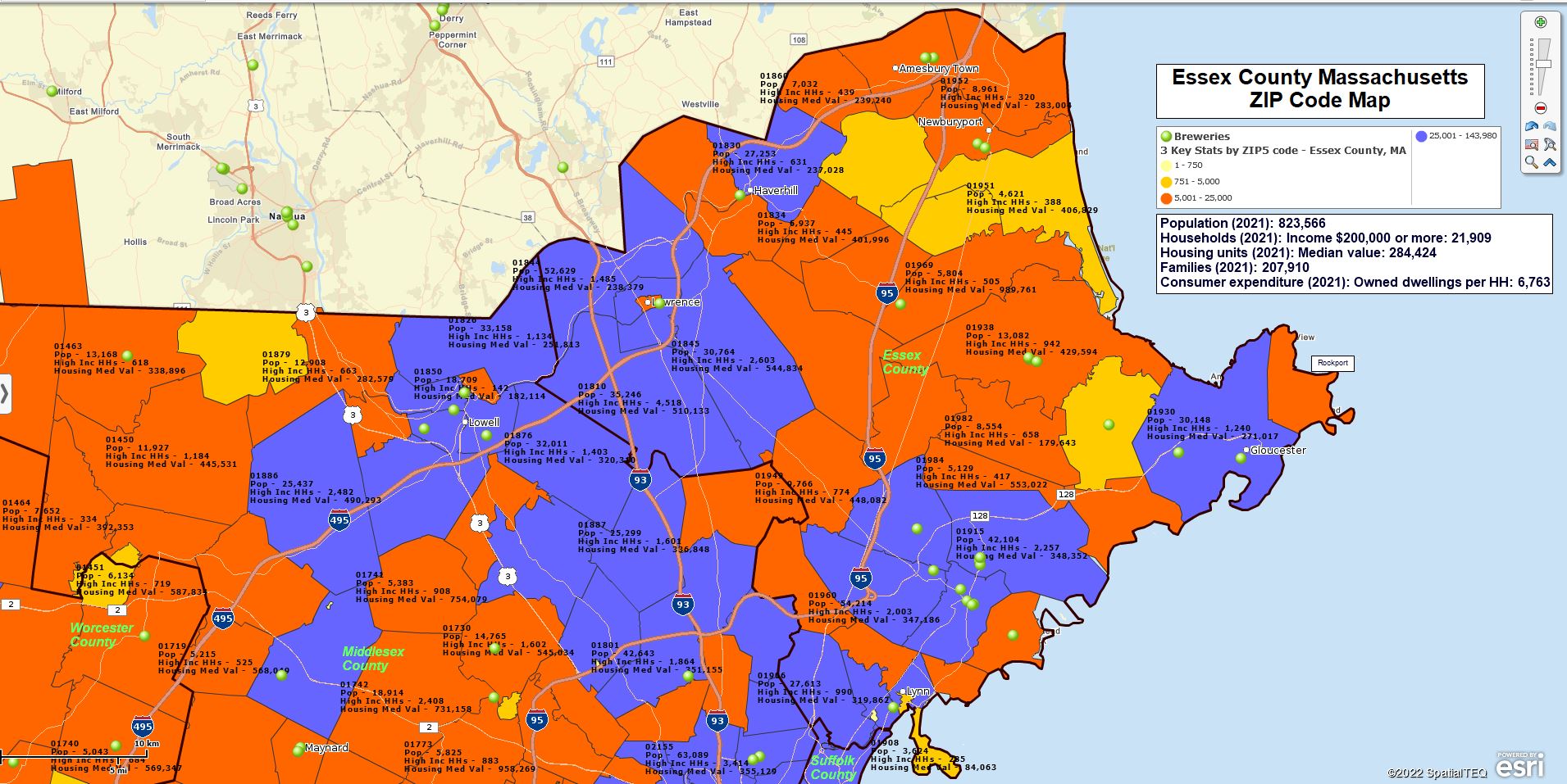
ZIP Code Mapping is What We Provide

Essex County, MA – ZIP Code Map

MapBusinessOnline ZIP code-related features include:

  • The ability to import a simple spreadsheet of ZIP codes into the map application for compelling map visualizations. We often refer to these maps as ZIP code maps.
  • The ability to color-code ZIP codes based on imported or demographic data. This process is referred to as ‘heat mapping.’ (In MapBusinessOnline, ‘heat mapping’ is also a feature we offer that shows concentrations of location points by numeric values. )
  • Sales territory mapping by ZIP code alignment. Sales territory mapping is a primary solution used by thousands of MapBusinessOnline customers. Sales territory maps are used by all kinds of industries, including construction businesses, franchise organizations, insurance companies, manufacturing concerns, medical systems, retail chains, service industries, and a host of other firms.
  • MapBusinessOnline Pro’s ability to create ZIP-to-ZIP origin/destination maps. We call these feature Batch Calculate. It can calculate accurate driving time or distance measurements between all points in one to two datasets. Talk about glorious.
  • Summarize demographic data by ZIP code or groups of ZIP codes for use within or outside MapBusinessOnline.
  • Search and Purchase Business Listings by ZIP or groups of ZIP codes. These paid-for search results can then be color-coded and exported.
  • The use of the ZIP code layer as a map background color-coded by demography or imported user data. I use this powerful feature all the time.

How Can I Export My ZIP Codes Segmented by Territory?

The above subject is a common technical support question from MapBusinessOnline sales territory management users.

Realize that by simply exporting the ZIP code layer from the Data Window view, a user can easily export all ZIP codes. Select the layer and click the Export button on the far right of the Data Window toolbar. Try it.

Accordingly, our development team made the export process operation for exporting all ZIP codes segmented by territory name a very easy-to-accomplish task.

Once you’ve created territories:

  1. Open the Data Window.
  2. Select the ZIP5 Code Map Alignment Layer in the Data Window dropdown. To be clear, you are exporting ZIP codes by Territory, but you must select the ZIP code layer.
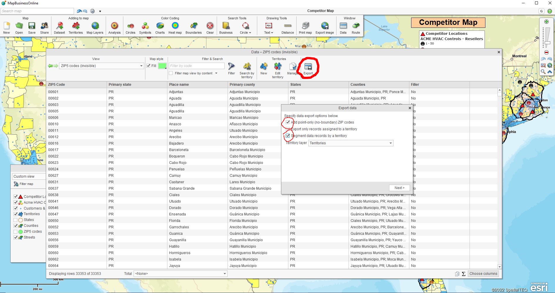
  3. Check all Three Boxes – As you begin the short export process, you will find three checkboxes that you should check off:
    1. Add point-only ZIP codes
    2. Export only records assigned by Territory.
    3. Segment records by Territory.
  4. Click the Export button on the far right of the Data Window toolbar.
  5. Save your exported file. The file will export as a comma delimited CSV file.

The user does not need to add a territory column to the ZIP code map view in the Data Window. This simplified export process will add the territory name column to your exported spreadsheet for you. As you can see, the check box option allows the user to include Point Zip codes which means you’ll be exporting all ZIP codes associated with each Territory.

Exporting ZIP Codes Using MapBusinessOnline

MapBusinessOnline users export ZIP codes segmented by Territory for multiple reasons:

  • To verify territory coverage areas and make sure there are no gaps.
  • To generate sales reports by Territory, franchise, store, or sales rep.
  • To clarify franchise territory ZIP code ownership or accountability.
  • To create a record of assigned sales territory ZIP codes for franchisee reference.
  • To display and track Zone pricing by ZIP code.

Note: Any MapBusinessOnline map layer (City Limits, Counties, Census tracts, and more)  can be exported from the Data Window exactly as ZIP codes are exported above.

Further ZIP Code Segmentation

While the Export button from the ZIP code layer is now optimized to segment output by territories, map creators can segment ZIP code, county, or other map layer output by using other data columns.

Use the Choose Columns button to add columns from imported data, the demographic catalog, or other geographic layers into your analysis. Then segment as required and export the resulting spreadsheets to CVS files.

Popular ZIP code and county segmentation themes include:

  • Customer segmentation – Segment groups of customers by area, customer type, sales activity, or by-product interest.
  • Demographic segmentation – Segment areas by demographic categories such as population or median income levels.
  • Calculated Data Columns – Combined columns using Calculated Data Columns in Map and Data. Basically a formula function by map layer.

Note: For advance segmentation across multiple locations at one-time purchase MapBusinessOnline Pro.

ZIP codes offer tremendous value for business mapping users when viewed as the most popular map layer. These mostly tiny jurisdictions are the geographic building blocks of our collective lives. Use them to organize your business mapping visualizations, and you’ll share compelling and informative map projects across your business.

And your peers and constituents will think you are a geo-genius. Not bad for a Map Geek.

_______________________________________________

Discover why over 25,000 business users log into www.MapBusinessOnline.com for their business mapping software and advanced sales territory mapping solution. The best replacement for Microsoft MapPoint happens to be the most affordable.

To access MapBusinessOnline, please register and download the Map App from the website – https://www.mapbusinessonline.com/App-Download.aspx.

After installing the Map App, the MapBusinessOnline launch button will be in the Windows Start Menu or Mac Application folder. Find the MapBusinessOnline folder in the Start Menu scrollbar. Click the folder’s dropdown arrow and choose the MapBusinessOnline option.

The Map App includes the Map Viewer app for free non-subscriber map sharing.

Please read customer reviews or review us at Capterra or g2crowd.

Contact: Geoffrey Ives at geoffives@spatialteq.com or Jason Henderson at jhenderson@spatialteq.com

Posted in Business Mapping Software blog post, How to instruction, Sales and marketing | Tagged , , , , , , | Leave a comment

Use Complete Addressing to Optimize Your Business Map

So you need to create a business map for a project at work. Maybe you are a business owner and know you need to view your business data geographically to make some critical decisions. Or perhaps your boss picked you from a list of people options and asked you to build a business map for the company. In which case, congratulations! It means she trusts you.

You spent some time online searching for the right business mapping software solution, and now it’s time to get down to brass tacks and generate a business map for your planning meeting next week.

The Prep Work

You must import a spreadsheet of locations to describe critical business issues with map views, especially if you support sales and marketing folks with business mapping. And if you’re working for a typical business, that location spreadsheet will have hundreds to thousands of location points. I have good news and bad news for you.

Here’s the good news: The data preparation component of your mapping project is the hardest part. Once you get past your first location-based spreadsheet and start working with the data on the map, you will love business mapping.

Ok, now the bad news: You should not shortcut the location spreadsheet.

What do I mean by a shortcut? Sometimes the prospect of developing a list of all customers, resources, patients, prospects, vendors, or other business locations, can be overwhelming for the new business mapper. So instead of plotting full address data, they plot using just State or just ZIP code locations.

Find the Best Data Available

We’re all so used to having downloadable, instantly available data. You should conduct some due diligence and see if you can find a spreadsheet with addresses or latitude and longitude coordinates that already exists in your business. Your business address data should be available from the accounting, marketing, and sales departments. They need addresses to send out invoices, marketing pieces, or sales offers. You may find administrative assistants around the office have client addresses neatly stashed in spreadsheets. Ask around. Beat the bushes. Have somebody compile address lists using the Internet. It may feel like a project, and it is, but the results will be worth the trouble.

The first place I would look is in your company’s CRM. Your CRM could be Salesforce, SAP, Oracle, ACT!, HubSpot, ZoHo, or another CRM software player. Customer Relationship Management software usually allows the export of customer lists to CSV or Excel files. Go there first.

For MapBusinessOnline, you’ll need a spreadsheet that includes the Name of the location plus separate columns for Address | City | State | ZIP code. Or a column for latitude and a column for longitude coordinates.

Many people come to us with spreadsheets with just Name and ZIP Code columns or Name and State. Unfortunately, these addressing options will not lead to a memorable business map, at least not memorable in a good way.

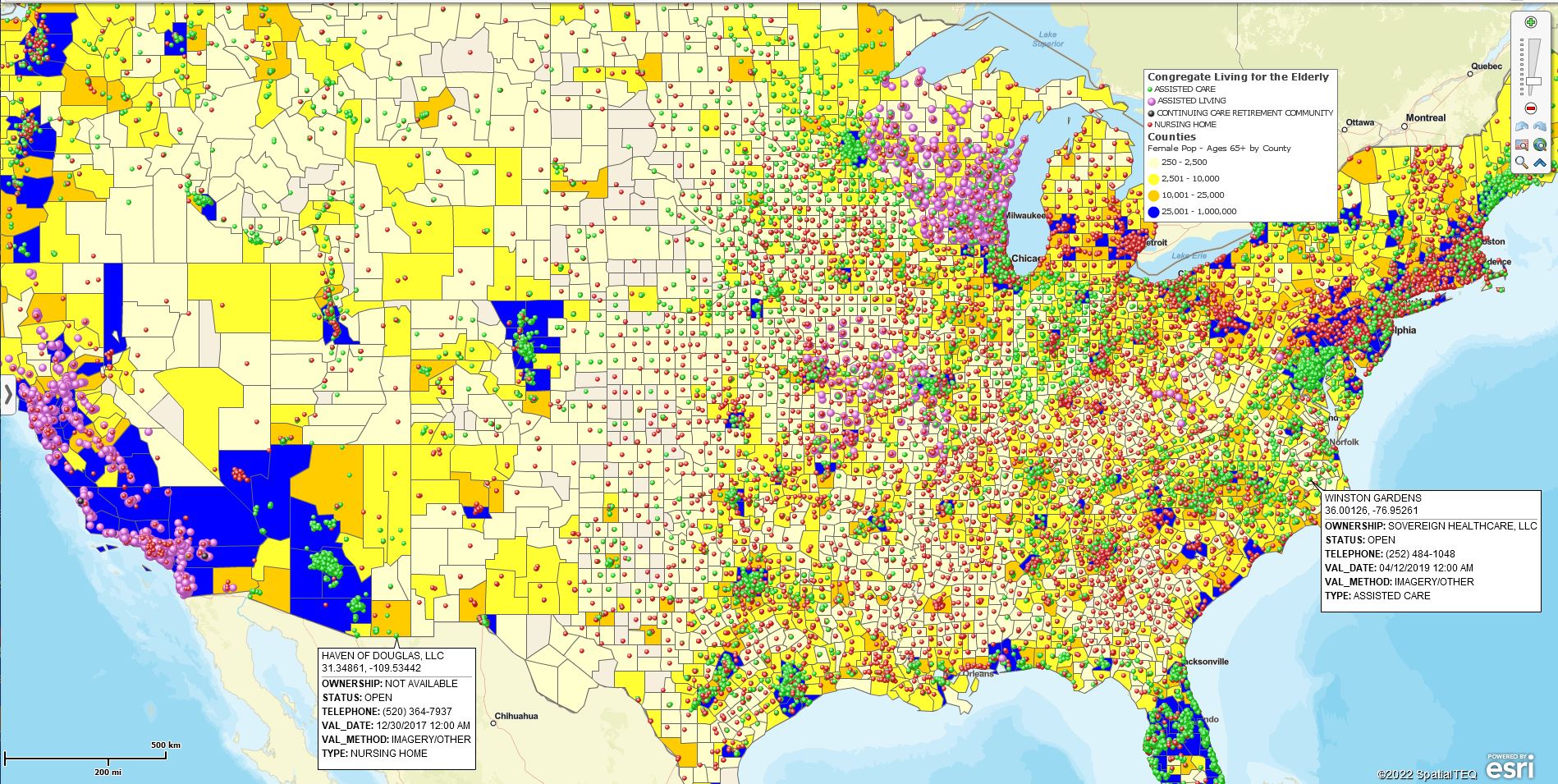
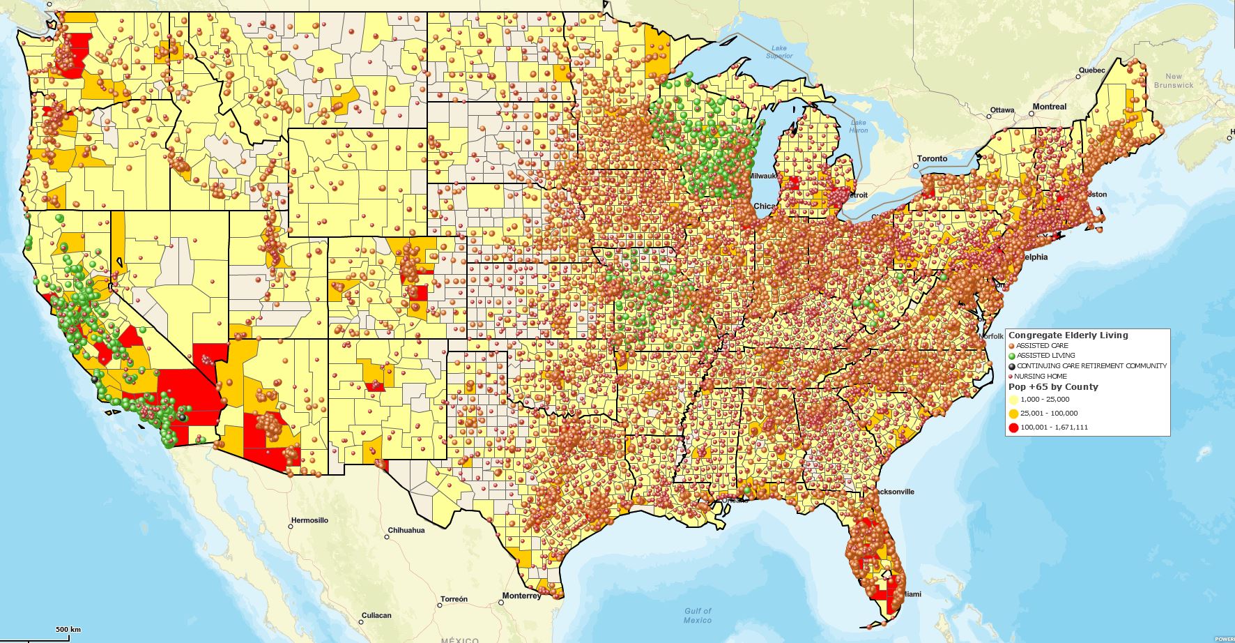
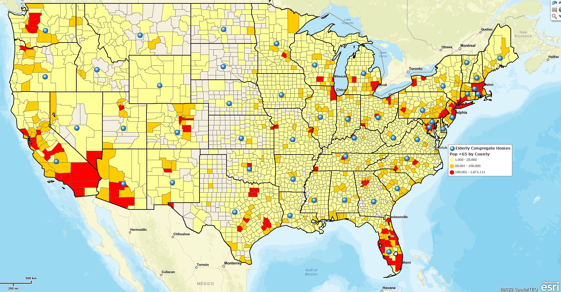
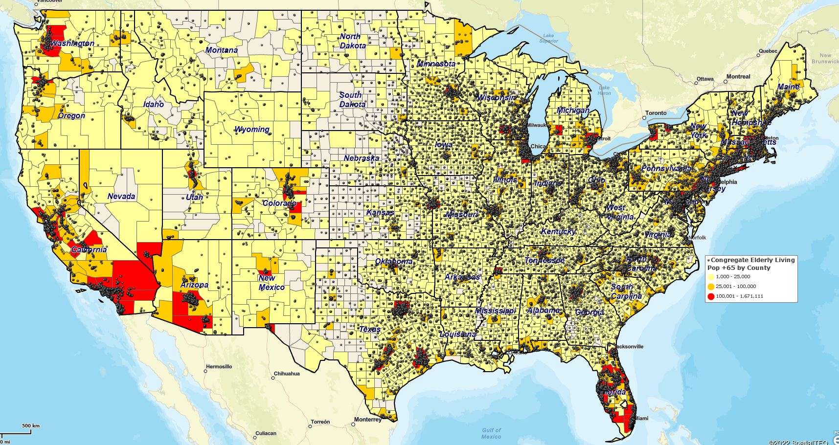
Compare the two maps below. The first shows congregate homes for the elderly imported by address and color-coded by type. The second uses the same data imported by the State only.

Elderly Congregate Homes by Address.

Elderly Congregate Homes by State.

See the difference? Note the big blue dots on the second map. They represent all those congregate homes from the first map geolocated by State only, not by address. When you import a spreadsheet by address or latitude and longitude coordinates, you derive the maximum benefit from your location data and mapping application. Additionally, importing by State, County, or ZIP code only leaves value out of your business map:

  • Map visualizations become meaningless.
  • Color-code options by classification or numeric value are lost.
  • Density views or heat-mapped activity no longer have an impact.

If you want to be a mapping hero, find your critical location data addresses. Otherwise, you better cancel that ticker-tape parade.

Dot Density Map

Here’s another example of the power of address-based location data. Using the same map and data above, I have shifted my symbolization of the address-based congregate home data. I am now using a relatively small, black location point. The data clearly shows groupings or clusters where many locations exist in a limited area.

Elderly Congregate Home Dot Density Map.

Dot Density Map quickly tells the map viewer where the action is. All those clustered areas indicate locations with plenty of older Americans. So if you don’t like Shuffle Board and rediscovering the hits from the 1950s, avoid those clustered dark areas.

So I think I’ve made my point—import location data with full addressing.

Once you’ve imported your data, use these articles to help yourself create a compelling and informative business map for your map viewer to view. Your boss will remember you for it. And maybe he’ll sponsor a ticker-tape parade. But don’t hold your breath.

_______________________________________________

Discover why over 25,000 business users log into www.MapBusinessOnline.com for their business mapping software and advanced sales territory mapping solution. The best replacement for Microsoft MapPoint happens to be the most affordable.

To access MapBusinessOnline, please register and download the Map App from the website – https://www.mapbusinessonline.com/App-Download.aspx.

After installing the Map App, the MapBusinessOnline launch button will be in the Windows Start Menu or Mac Application folder. Find the MapBusinessOnline folder in the Start Menu scrollbar. Click the folder’s dropdown arrow and choose the MapBusinessOnline option.

The Map App includes the Map Viewer app for free non-subscriber map sharing.

Please read customer reviews or review us at Capterra or g2crowd.

Contact: Geoffrey Ives at geoffives@spatialteq.com or Jason Henderson at jhenderson@spatialteq.com

Posted in A story, Business Mapping Software blog post, How to instruction | Tagged , , , , , | Leave a comment

Why Demographic Data & Business Mapping Work So Well Together

MapBusinessOnline combines an accurate and easy-to-use business mapping software with the Census Bureau’s library of demographic data. I thought exploring a few sorted, and filtered views of demographic data as applied to a business map might be helpful.

Let’s jump right into Median Income. The demographic categories include overall median income levels and the number of people who make specific gradations of income. There’s a difference.

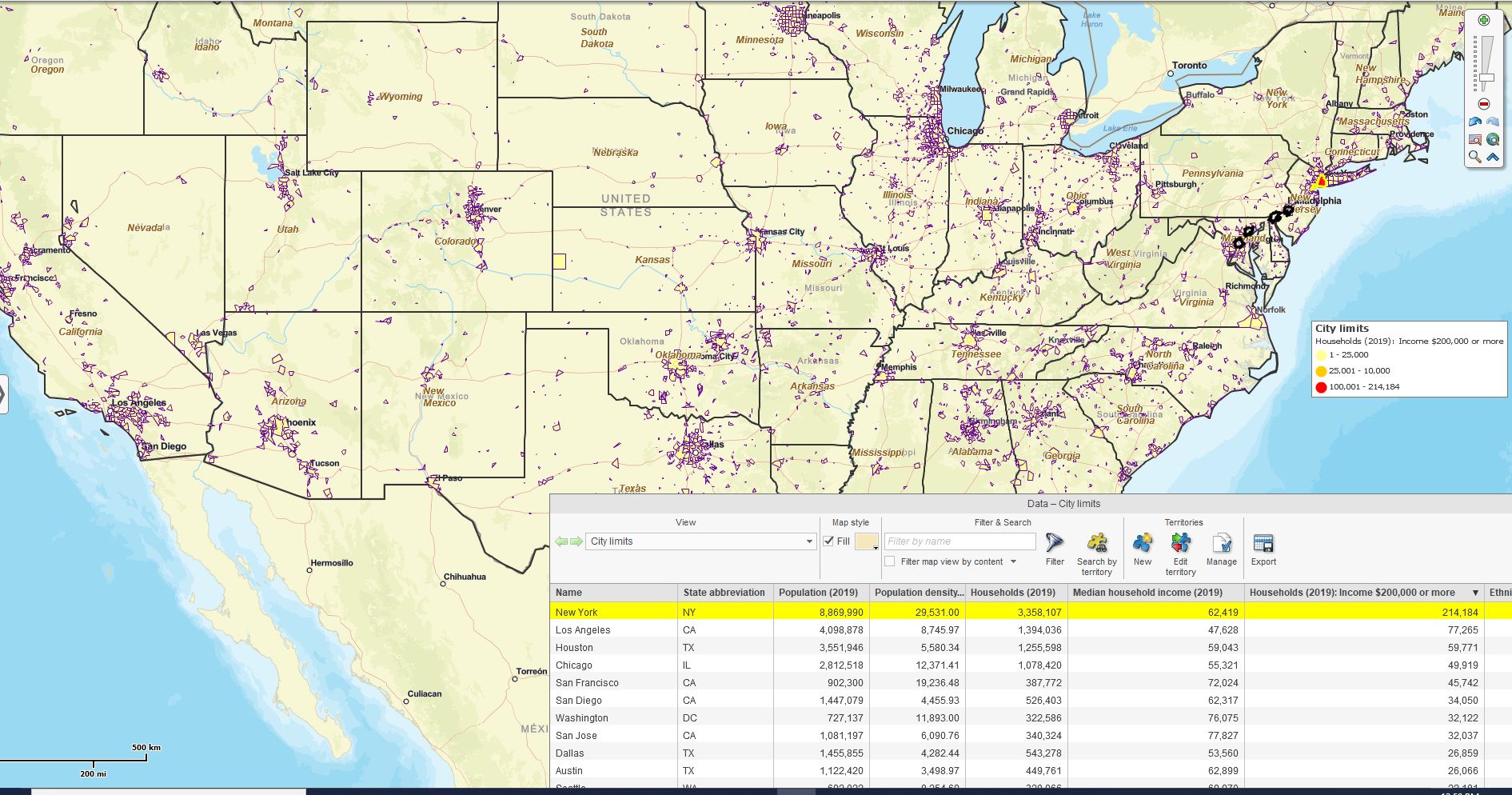
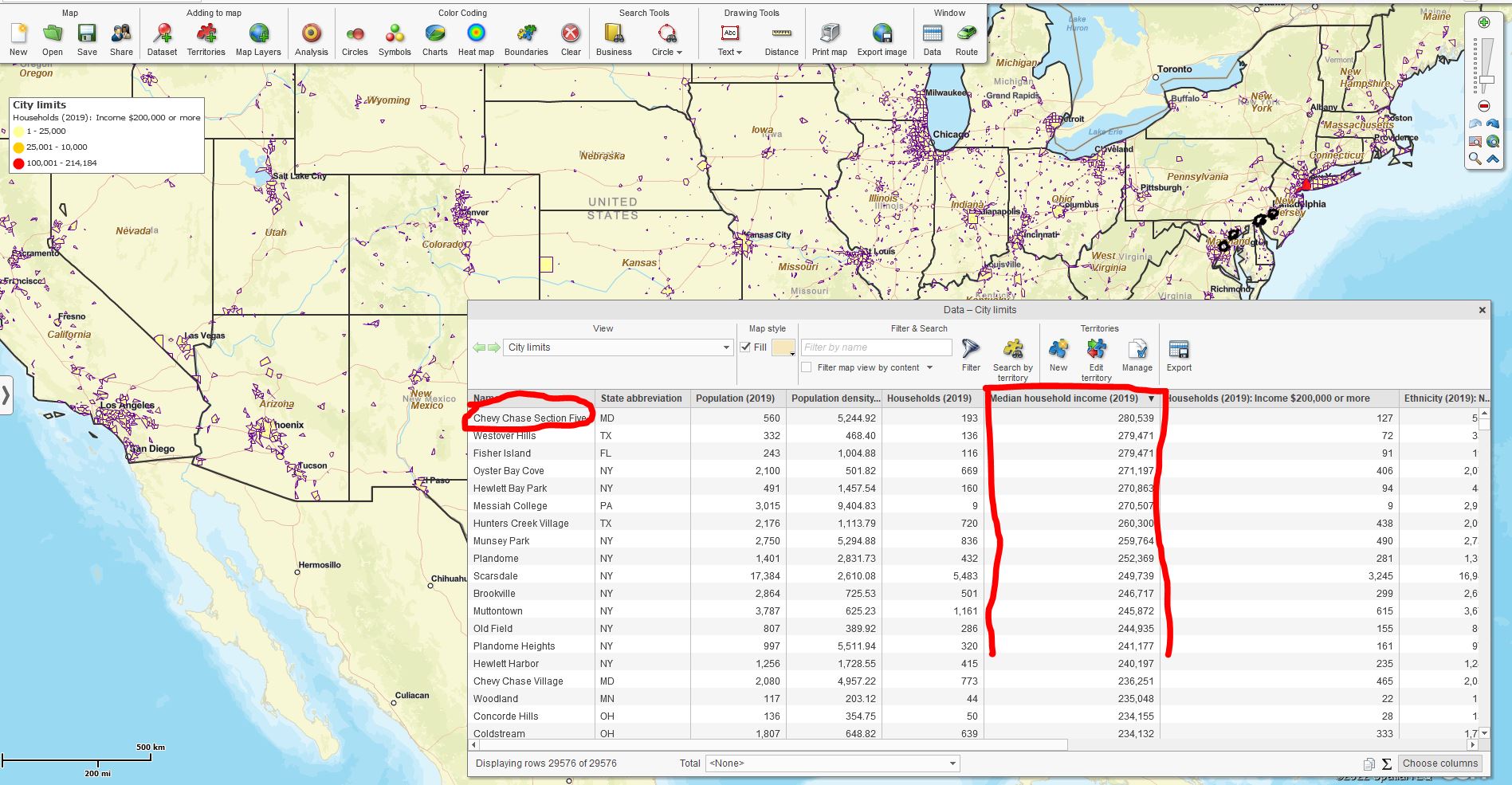
Suppose we add Median Income for a year to the map by the City Limits layer. In that case, we can color-code that information by City Limit and apply a descending sort from highest to lowest Median Incomes.

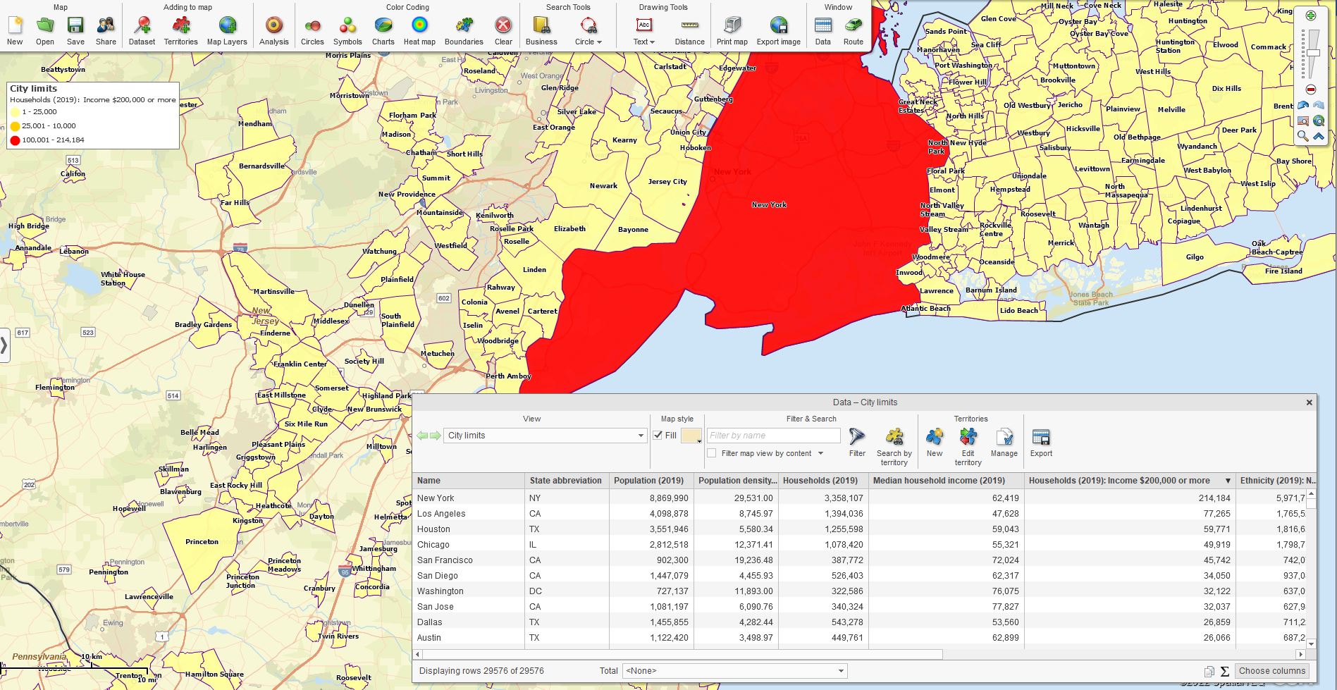
This thematic map view exposes the city areas with the highest number of households with income levels higher than $200,000. There’s only one city limit area with more than 100,000 households with income levels higher than $200,000 – New York City.

This thematic map reflects the number of households with the highest income.

Number of Households by City with Income Over $200,000.

Zoomed on New York City:

Most Households with Median Income Over $200,000

Alternatively, one can look at the tabular view of the City Limits map layer and add the column of demographic data: Median House Hold Income (2019). This result shows the highest income values by city. Median income means the values indicate the median point (not the average) between the highest and lowest.

The following analysis displays Median Income by dollar value. You can filter the results to show the top X cities. My map displays the top 20 cities with the highest median income. New York City is not on that list. Chevy Chase and other cities have more median income in general.

Chevy Chase has the Highest Median Income Level.

One possible conclusion from this analysis, comparing the number of high-income households to the highest median-income cities, is that retailers should focus first on New York City based on the number of households with high income and the population density. If you can make it there, you can make it anywhere. It’s up to you..retailer.

At any rate, the map creator can export that list of top 20 Median Income cities and send it to colleagues for discussion and decision-making. Perhaps you’ve got outlets in New York and are looking to expand elsewhere.

Additional Helpful Demographic Categories

Demographic data from the Census Bureau included in MapBusinessOnline offers hundreds of subjects, many with multiple numeric segments. I’ve found particular subjects to be very helpful:

  • Hispanic and Non-Hispanic Populations – Generalizing assumptions about ethnicities can be tricky, but there are practical reasons for considering ethnic backgrounds. Certain products sell well to specific groups, so race is essential from a marketing perspective. For instance, business requirements for hiring Spanish-speaking employees can make such analysis necessary.
  • Consumer Expenditures – General categories of consumer expenditures are helpful in broad definitions of market potential, perhaps informing site selection options or finetuning an addressable market.
  • Housing and Rental Data – Great for real estate market considerations by region. Helpful for financial institutions too.
  • Head of Household Data – Female or Male head of household categories tends to vary by region, income, and other factors. Still, analysis of employment opportunities by the city can benefit from these segments.

Explore the categories accessible from your MapBusinessOnline subscription to find demographic categories that may apply to your specific industry.

Gather the Children and the Old Duffers

Age Segmentation – Breaking down populations by age, income, and ethnicity by segment can help expose specific demographic trends. The demographic data includes population by age, households by median income levels, and other segmented breakdowns.

Demographic segmentation provides a way to drill deeper into the data. For instance, home care agencies can look at specific age sections and analyze those segments against relevant business data. They might determine that the females, ages 75 to 79, have significantly higher incidents of broken ankles and other injuries, which could lead to new preventative measures across the agency.

MapBusinessOnline has a feature called Calculated Data Columns that allows the map creator to combine multiple demographic segments of like values for analysis by map layer. The Calculated Data Columns tool allows the map creator to present all households with median household income levels from $75,000 to $149,000 – three demographic segments – by ZIP code and consider the segment’s estimated purchases of Personal Care Products over the last two years.

The map creators and marketing managers can get creative with their analysis. Calculated Data Columns by City or Market Area (territory) is the perfect tool for:

  • Defining an addressable market. Explore the various demographic segments by area and jurisdiction. Drill into demographic details to better match product use cases to population segments.
  • Finetuning a site selection process. Create ZIP code or area demographic profiles. Know as much as possible about where you are successful today and bring that information to bear on new operation sites.
  • Developing franchise market territories. Connect product or service offerings with known demographic prospect pools. Justify the franchisee’s investment.

Census Bureau Demographic data categories enable demographic mapping. These visualization and analytical capabilities are made for each other, like peanut butter and jelly or lobster and melted butter.

Lobster and Jelly Sandwich.

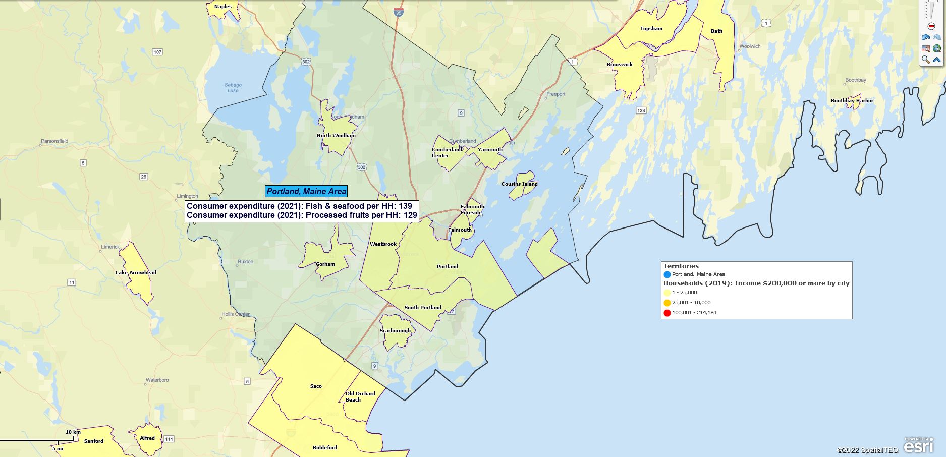
Which, BTW, would be included in the demographic categories:

  • Fish and Seafood per HouseHold.
  • Processed Fruit per Household.

_______________________________________________

Discover why over 25,000 business users log into www.MapBusinessOnline.com for their business mapping software and advanced sales territory mapping solution. The best replacement for Microsoft MapPoint happens to be the most affordable.

To access MapBusinessOnline, please register and download the Map App from the website – https://www.mapbusinessonline.com/App-Download.aspx.

After installing the Map App, the MapBusinessOnline launch button will be in the Windows Start Menu or Mac Application folder. Find the MapBusinessOnline folder in the Start Menu scrollbar. Click the folder’s dropdown arrow and choose the MapBusinessOnline option.

The Map App includes the Map Viewer app for free non-subscriber map sharing.

Please read customer reviews or review us at Capterra or g2crowd.

Contact: Geoffrey Ives at geoffives@spatialteq.com or Jason Henderson at jhenderson@spatialteq.com

Posted in Business Mapping Software blog post, How to instruction | Tagged , , , , , | Leave a comment

Site Selection & Decision-Making Tools for Market Expansion

One key element of business planning that lends itself nicely to business mapping is site selection. Whether your company is building from scratch or rebuilding, new sites are always a significant investment for any business. Selecting the best locations for a new building, storefront, manufacturing facility, or warehouse can be stressful, complex, and challenging.

MapBusinessOnline.com business mapping software offers a variety of features that can help organize the site selection process and narrow down the options so that a decision-making team can sort through impacting factors and land on the best five to ten candidates.

Depending on the extent of your site selection requirement,  you may require several types of maps that work together to narrow down the options. For example:

  • Urban area site selection map. A first-pass site selection process could determine the best two or three cities to support your expansion plan. Considerations at this level could include the best neighborhoods, crime stats, school systems, and perhaps a retail outlet inventory.
  • Demographic mapping to investigate customer or workforce characteristics. Population, ethnicity, and med income levels are likely demographic indicators.
  • Real estate maps display property options for employee home purchases, rental options, and city benefits.
  • Competitor maps that make clear any impact competing interests may have on your plans are valuable. Competitor maps also tend to illuminate labor pluses and minuses for the area.

MapBusinessOnline Standard and Pro provide various location-based tools to help your business sort through and select the optimum sites to put in front of your decision-making team.

Getting the City Right

In new site selection, choosing the proper city may not be up to you and your team. But in many cases, city selection is a necessary part of the process.

What urban area makes the most sense for your latest business venture? Business maps present a variety of map layers that can help define urban areas and match specific characteristics to your business requirements:

  • Demographic Profiles – Demographic layers offer population, income, age, ethnicity, and housing statistics. These factors can be thematically layered on the map or textually noted at the address or jurisdiction levels. ZIP code demographic profiles of areas where business succeeds today can be used to find similar regions around the nation that reflect the same demographic characteristics.
  • City Climate – Where a city is located has an impact – today more than ever before. If you’re building a warehouse that will last fifty years, coastal Florida might not be the wisest choice in the face of inevitable sea level rise. Likewise, strawberry storage may move north, and east as rising temperatures affect irrigation and soil conditions. Or perhaps you’re considering a mountain resort for your new call center site? Check future ski resort plans and hourly pay rates to ensure you have the labor pool required for a call center.
  • Housing values and City Services should be considered. Don’t locate a truck depot in an upper-crust real estate neighborhood or a high-crime area. Make sure water systems and power sources match your requirements.

It’s a wicked big country, and organizing your site selection at the city level is helpful. Sort or filter city records based on demographic and financial criteria. Limit options to the top five to fifteen urban area candidates for site placements. Business mapping map visualizations and tabular datasheet views offer easy and quick ranking comparisons.

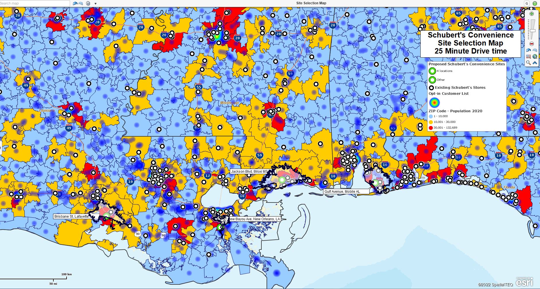
Final retail site selection map using MapBusinessOnline.

Customer Requirements Matter

Strong consideration needs to be given to the nature of the customer base. The customer is king, especially for retail site selection. Site selection for retailers and services such as ophthalmologists, medical specialists, and dentists must accommodate the customer.

Ask yourself customer-related questions that help define your business customer sweet spot. Then look for those demographic characteristics within existing business areas. ZIP codes and Cities can be profiled in this way and then matched with areas surrounding your target cities.

  • Which population segments are most important to the business? Where do these people live?
  • What is the drive time tolerance of the average customer?
  • What products and services sell best in certain climates?
  • Explore consumer expenditure data in the Census Bureau Demographic categories available in MapBusinessOnline. Expose ZIP codes or areas where relevant expenditures proliferate.

A well-crafted site selection map should contain location datasets of customers by address, type, and historical sales activity. Customer concentrations are displayed by heat map layering or by color-coding address points. Usually, sites are selected in areas of high customer density to save on transportation and staffing costs for sales, service, and end-user travel.

Study informative customer map visualizations.

Transportation Considerations

Easy access to a loading dock or a front door is a concern for service deliveries and customer walk-ins. As site location options narrow, it is always a good idea to drive the area around the proposed site to get ground truth. What are the local speed limits, turn restrictions, and highway access roads?

It may make sense to procure business listings of vital support services by area of interest. Business Listings are a service for a fee within MapBusinessOnline. These downloadable data points can be color-coded on maps to display business locations by type. For instance, call center locations may require phone technicians, cleaning services, day-care centers, and emergency point-of-care service locations.

Mapping services can generate optimized vehicle routes that describe the most efficient ways in and out of an area. Often major cities come with traffic bottlenecks. London and New Orleans come to mind. Issues like parking, gas station locations and turn restrictions can turn what appears to be a simple route on paper into an afternoon nightmare for an unaware driver. Explore those key routes by driving them. MapBusinessOnline offers optimized vehicle routing with turn-by-turn directions. Keep an eye out for the PoPo.

Be sure to view highway and local road networks on your business map. Consider downloading business listings for essential transportation support, such as service stations, gas and EV charging stations, and car parts stores.

Driving Time & Distance Analysis

MapBusinessOnline Pro offers advanced driving time and distance analysis, which helps build your site selection map project. Use MapBusinessOnline Pro to conduct the following research:

  • Develop driving time or distance calculations between two disparate datasets. Compare facility site candidate addresses to resource and customer address lists to assess proximities.
  • Create multiple drive time territories at once for a more thorough visual and tabular analysis.
  • Generate sales potential reports and employee statistics using business listings and industry data.
  • Find and compare the nearest resources, customers, and prospects to site selection candidates.

Develop market profiles using drive time or distance analysis.

Workforce Considerations

Generally, new branch locations will require a workforce. Labor may be in short supply in some urban areas. Census Bureau population demographic data is typically available in business mapping applications. Coupled with Labor Bureau employment statistics, your site selection team can determine the critical metrics for optimum workforce pools.

Key elements to a labor search might be:

  • Knowledge of significant employers in the area. Is the labor marketplace made up primarily of retailers – grocery, department, or convenience stores? Or are there manufacturing businesses in the area? Which may indicate a higher skilled labor force.
  • What language skills are required for new service centers? A check of the Hispanic population demographics may reveal an excellent or lousy labor pool for alternative languages to English, depending upon your business.
  • Household demographic data categories can also suggest whether or not labor resources exist in the targeted areas that match job requirements.

Competing Businesses

Another type of business map we often talk about is a competitor map. Competitor maps show the most viable competitor locations to the originating business. When developing site assessment maps, it may be necessary to include competitive companies in your map project. Find competing business locations using the MapBusinessOnline Business Listing data service mentioned above.

Business listings include firmographic information such as sales estimates and employee counts. A competitor dataset in the site selection map can indicate areas saturated with sales or service coverage.

Quality of Life Areas

Any business expansion plan’s site selection process must consider the employee’s quality of life. Essential services and safety are always necessary.

  • Is the surrounding area a safe and fulfilling place to live?
  • Are commuting times for employees and customers reasonable?
  • Are essential life support services within reasonable distances of employee living areas?

Maps should reflect the inventory of affordable housing, medical service locations, elementary and secondary schools, and grocery and pharmacy stores. These critical location addresses are available through MapBusinessOnline business listings.

Selecting Site Candidates

With an idea of which areas suit your site selection needs, you are ready to place site selection locations on the site selection map. The city map suggested above now has a list of favored cities. Export that filtered city list from the Data Window and import it into a new site selection map. Save your preferred city map for reference. Or use your city map as the base map for your site placements.

Once you’ve gathered a set of proposed site addresses or latitude and longitude coordinates, create a spreadsheet of those locations and import into MapBusinessOnline using the Adding to Map, Dataset option on the Master Toolbar. Include columns for procurement costs, property descriptions, and other relevant data. Perhaps include a column for ranking.

Add other resource data and industry-related services to your map as layers. Your map will begin to take shape as a decision-making tool, providing visualization and tabular data views required to narrow down your site selection options and inform the selection process.

By generating these site selection maps as an overall map project, your business can consider the location-related aspects of new site selection, paving the way for a successful expansion of your business and new opportunities for your constituents.

_______________________________________________

Discover why over 25,000 business users log into www.MapBusinessOnline.com for their business mapping software and advanced sales territory mapping solution. The best replacement for Microsoft MapPoint happens to be the most affordable.

To access MapBusinessOnline, please register and download the Map App from the website – https://www.mapbusinessonline.com/App-Download.aspx.

After installing the Map App, the MapBusinessOnline launch button will be in the Windows Start Menu or Mac Application folder. Find the MapBusinessOnline folder in the Start Menu scrollbar. Click the folder’s dropdown arrow and choose the MapBusinessOnline option.

The Map App includes the Map Viewer app for free non-subscriber map sharing.

Please read customer reviews or review us at Capterra or g2crowd.

Contact: Geoffrey Ives at geoffives@spatialteq.com or Jason Henderson at jhenderson@spatialteq.com


Posted in Business Mapping Software blog post, How to instruction | Tagged , , , , , , , | Leave a comment

Why Would Your Business Invest in a MapBusinessOnline Subscription?

Companies often turn to MapBusinessOnline business mapping software to solve problems, set up location-based reporting, or explain business trends. That’s why every day, we have a group of new subscribers exploring the various ways MapBusinessOnline can help them expand their e-commerce or improve operational efficiencies.

But how do you know if MapBusinessOnline can assist your business?

Geography is Important to Your Business

You might think geography is not crucial to your business. And for local convenience store retailers, that may be somewhat true. But for most companies, geography is critical to their day-to-day success.

Geography is essential to your business if you:

  • Deliver products and services across a wide area more extensive than a single ZIP Code.
  • Support customers in the field with traveling technicians or salespeople.
  • Monitor nationwide or regional customer sales activity.
  • Plan on expanding your business to new areas of the country.
  • Have existing or plan to create sales territories.
  • Support multiple branch locations.
  • Analyze sales by ZIP code, county, or state.
  • Are dependent upon suppliers from around the nation and the world.
  • Manage a chain of retail stores.
  • Conduct multiple site assessments every month or year.
  • Consider driving times or distances relevant to your business.
  • Work for a large enterprise, insurance company, bank, or manufacturer.

Business mapping software provides map visualizations of your business that will geographically define where revenue is generated and identify areas of future market potential for your products and services.

MapBusinessOnline provides the USA and Canadian map backgrounds and map layers required for accurate and compelling geographic business maps. Map controls include color adjustments, transparent map layers, and text box labels that present data descriptions. All these map features combine to inform your map viewer’s business awareness.

Posting Business Information by Territory Using MapBusinessOnline

One reason geography can positively impact business planning and expansion is that geography provides the perfect platform to view business demographically. This brings us to a second way MapBusinessOnline can help improve your business.

Demographic Information is Important to Your Business

The US Census Bureau provides a wealth of information in the form of demographic data. Fortunately for Americans and map makers, all Census Bureau demographic data is published by location component – primarily by ZIP code, county, and state. MapBusinessOnline’s extensive library of demographic subjects examines how all American citizens live, spend money, and consume services.

Demography is vital to your business if you:

  • Sell consumer products in the United States.
  • Market to groups of people by gender, ethnicity, or age.
  • Define your best customer by income bracket.
  • Sell products in significant consumer product categories.
  • Are considering expanding outside of a well-understood USA business region.
  • Offer franchise business opportunities to investing entrepreneurs.
  • Manage a sales or marketing department.

Map creators can sum Demographic data within MapBusinessOnline across like categories such as age or income. In this way, all Americans ages 65 and up can be classified as one demographic group by ZIP code or county for in-depth analysis by area. Thus, MapBusinessOnline is the perfect marketing analysis tool for any back scratcher sold in the USA.

You Have Additional Relevant Data Layers

Business map projects for analysis or report writing will often require, and benefit from, the addition of relevant map layers to the analysis. These relevant additional data layers could be sales record spreadsheets, industry-specific marketing data, or even MapBusinessOnline business listings with firmographic data adding relevant business points to your map project.

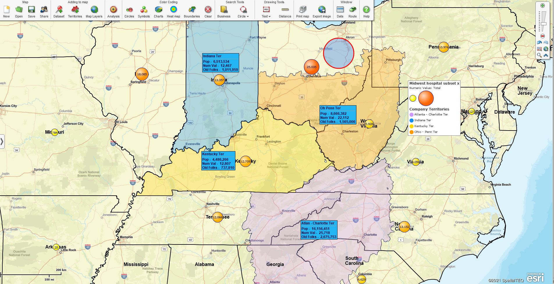
Using Color-coded Territories by Map Layer to Present a Business Model.

At the center of your map visualization project is the map application itself. Business mapping software is a kind of easel for location data offering the ability to present a variety of location-based data layers in an easy-to-use database management array. The mapping system as a data visualization tool, coupled with map jurisdiction layers, pulls together the final analysis of relevant data to the problem. Business maps, carefully crafted, provide solutions:

  • Business maps help sell franchises.
  • Business maps organize field service technicians.
  • Business maps balance sales territories
  • Sales territory maps inform and coordinate sales teams.
  • Demographic maps expose new markets and suggest new areas of market development efforts.
  • Optimized routing maps suggest the most efficient routes.
  • Business maps generate reports for transportation networks.

Given all the reasons business mapping software benefits any organization focused on profitability and growth, it isn’t easy to understand how a business can get by without software like MapBusinessOnline.

_______________________________________________

Discover why over 25,000 business users log into www.MapBusinessOnline.com for their business mapping software and advanced sales territory mapping solution. The best replacement for Microsoft MapPoint happens to be the most affordable.

To access MapBusinessOnline, please register and download the Map App from the website – https://www.mapbusinessonline.com/App-Download.aspx.

After installing the Map App, the MapBusinessOnline launch button will be in the Windows Start Menu or Mac Application folder. Find the MapBusinessOnline folder in the Start Menu scrollbar. Click the folder’s dropdown arrow and choose the MapBusinessOnline option.

The Map App includes the Map Viewer app for free non-subscriber map sharing.

Please read customer reviews or review us at Capterra or g2crowd.

Contact: Geoffrey Ives at geoffives@spatialteq.com or Jason Henderson at jhenderson@spatialteq.com

Posted in Business Mapping Software blog post, Sales and marketing | Tagged , , , , , | Leave a comment